- Except as otherwise allowed by this bylaw, USES and DEVELOPMENT in each ZONE shall be in accordance with the USES listed for the ZONE and all the appropriate requirements of this bylaw.
- Intent, impact, and definition of the use, among others, will be considered when determining whether or not a use is permitted.
- If a USE is not listed as permitted, it shall be interpreted as not permitted.
Loading…
section 1.0
General Administration
1.1
Purpose
- This bylaw provides for orderly, efficient, economic, and environmentally and socially responsible development in Dawson City (Dawson) by:
- implementing the goals and directions of the City of Dawson Official Community Plan (OCP)
- establishing land use ZONES and associated regulations to control the use, location, type, and level of development allowed to occur on a PARCEL of land within the City of Dawson municipal boundary
- setting out rules and procedures, information requirements, and processes to regulate land use and development within the City of Dawson municipal boundary
- maintaining and enhancing the unique character and history of Dawson
section 1.0
General Administration
1.2
Enabling Legislation
- This bylaw has been passed in conformance with the Yukon Municipal Act.
section 1.0
General Administration
1.3
Basic Provisions
1.3.1
Application
- This bylaw shall be applicable to all land, BUILDINGS, and STRUCTURES within the municipal boundary of the City of Dawson (the City).
1.3.2
Conformity
- Land, including air space, and BUILDINGS and STRUCTURES shall not be located in an area or constructed, altered, or used except as specifically permitted in this bylaw.
1.3.3
Severability
- If any section, subsection, sentence, clause, or phrase of this bylaw is for any reason held to be invalid by the decision of any court of competent jurisdiction, the invalid portion shall be severed from the bylaw and such decision shall not affect the validity of the remaining portions of this bylaw.
1.3.4
Metric Units
- Metric units are used for all measurements in this bylaw. Imperial units are provided for convenience only.
1.3.5
Applicable Regulations
- Where this bylaw sets out two or more regulations that could apply to a situation, the most stringent regulation shall apply.
- Where this bylaw sets out both general and specific regulations that could apply to a situation, the specific regulation shall apply
section 1.0
General Administration
1.4
Zoning Maps
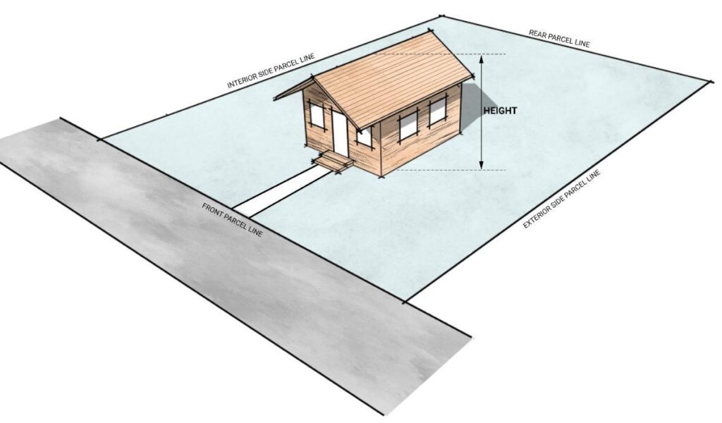
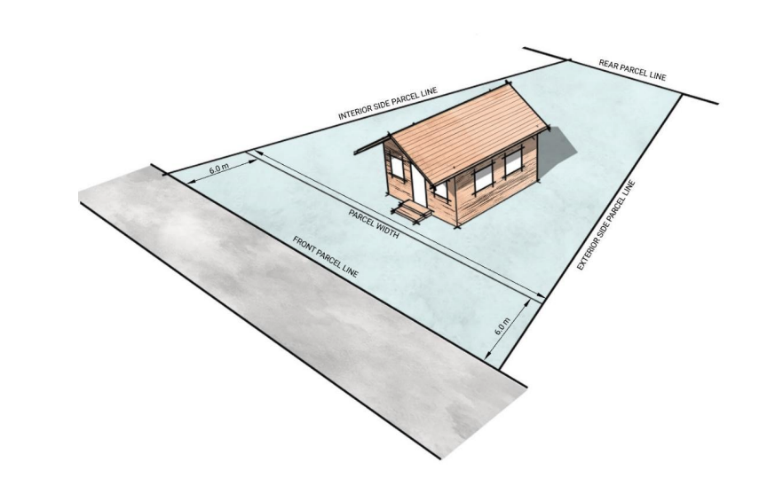
- The municipality is divided into land use ZONES and the boundaries of those ZONES are shown on the zoning maps, attached as Schedule A Zoning Map: Valley, Confluence, and Bowl, Schedule B Zoning Map: Historic Townsite, and Schedule C Heritage Management Map: Historic Townsite forming part of this bylaw.
- The boundaries on the zoning maps shall be interpreted as follows
- Where a ZONES boundary is shown as following a HIGHWAY, RIGHT-OF-WAY, or WATERCOURSE; the centre line of the highway, RIGHT-OF-WAY, or WATERCOURSE shall be the zone boundary.
- Where the ZONES boundary does not follow a legally defined boundary, and where the distances are not specifically indicated, the location of the ZONES boundary shall be determined by referencing topographic and scaling information from the zoning maps.
- When any public roadway is closed, the lands shall be rezoned to have the same zoning as the ABUTTING land.
- When different ZONES govern ABUTTING lands, the centre of the roadway is the ZONE boundary, unless the boundary is shown clearly following the edge of the roadway.
section 1.0
General Administration
1.5
Compliance with Other Legislation
- In addition to complying with this bylaw, a person applying for a DEVELOPMENT PERMIT or CHANGE OF USE is responsible for ascertaining and complying with the requirements of any other applicable municipal, territorial, or federal legislation.
- The issuance of a DEVELOPMENT PERMIT does not relieve the property owner from complying with any easement, covenant, lease, scheme, or development agreement that affects the application.
section 1.0
General Administration
1.6
Uses and Regulations
section 1.0
General Administration
1.7
Non-Conforming Uses
- Non-conforming use of land, BUILDINGS, or STRUCTURES will be dealt with according to the provisions of the Yukon Municipal Act, as amended from time to time.
- BUILDINGS or STRUCTURES or DEVELOPMENT constructed without a required permit shall not be considered a lawful non-conforming use and will be required to comply with all requirements of this bylaw.
- For non-conforming PARCEL sizes:
-
- PARCELS created before the approval of this bylaw that are less than the minimum dimensions, or more than the maximum dimensions required of the ZONE they are in, shall be considered to be conforming PARCELS for the purposes of this bylaw.
- A PRINCIPAL or SECONDARY USE is permitted on a PARCEL less than the minimum PARCEL size in that ZONE provided that the DEVELOPMENT otherwise complies with all the regulations of this bylaw.
- REAR AND SIDE YARD SETBACKS may be reduced by the same percentage that the PARCEL is less than the minimum for the ZONE.
section 1.0
General Administration
1.8
Applications in Process
- An application for a DEVELOPMENT PERMIT that is received in its complete and final form prior to the effective date of this bylaw shall be decided upon within 90 days of this bylaw coming into effect.
- No time extension shall be granted to any DEVELOPMENT PERMIT issued under this section for which DEVELOPMENT has not commenced within 12 months.
section 1.0
General Administration
1.9
Copy of Record and Availability
- The duties of the DEVELOPMENT OFFICER shall include:
- Keeping and maintaining for inspection by the public during normal office hours;
- a copy of this bylaw, as amended,
- all DEVELOPMENT PERMIT applications, including the decisions and the reasons therefore
- Ensuring that copies of the bylaw and amendments are obtainable by the public at the prescribed fee.
- Keeping and maintaining for inspection by the public during normal office hours;
section 1.0
General Administration
1.10
Illustrations
- In the event of any inconsistency between the text of this bylaw and any figure or illustration, the text shall govern.
section 2.0
Definitions
2.1
Interpretation
- Words written in uppercase in this bylaw indicate a definition for the word is included in Section 2.0 Definitions.
- Typical USES listed as examples in the definitions are not intended to be exclusive or restrictive.
- When a specific USE does not conform to the wording of any USE definition, or generally conforms to the wording of two or more definitions, the DEVELOPMENT OFFICER may use discretion to determine which USE, if any, is most appropriate in character and purpose.
- The term “City,” when capitalized in this bylaw refers to the City of Dawson as a local government; whereas “city” when in lowercase refers to lands located within the municipal boundary, which are generally referred to as the community of Dawson.
section2.0
Definitions
2.2
General Definitions
Filter
A ABUT
ABUT or ABUTTING means immediately contiguous to or physically touching. When used with respect to PARCELS or sites, this definition refers to PARCELS or sites that share a common property line or border.
A ACCESSORY BUILDING
ACCESSORY BUILDING or STRUCTURE means a BUILDING or STRUCTURE, that is associated with the PRINCIPAL USE of the PARCEL but is ancillary or subordinate to the PRINCIPAL BUILDING.
Examples of ACCESSORY BUILDINGS include garages, storage sheds, small-scale greenhouses, or workshops. Examples of ACCESSORY STRUCTURES include carports, gazebos, picnic pavilions, docks, decks, or fences.
A ADDITION
ADDITION means a new STRUCTURE, or portion of a STRUCTURE, added to an existing STRUCTURE in a manner that creates a shared wall.
A ADJACENT
ADJACENT means land that is contiguous to and accessible from a site, including land that would be contiguous if not for a public road, lane, walkway, utility lot, underground pipeline, power line, drainage ditch, or similar feature. This definition does not include land separated by a stream or river.
A AGRICULTURE
AGRICULTURE means growing, rearing, harvesting, and selling agricultural crops and/or LIVESTOCK; this includes processing the primary agricultural products harvested, reared, or produced on the PARCEL. This definition does not include small-scale gardens on a residential property.
A ALCOHOL SALE
ALCOHOL SALE means the retail sales of any and all types of alcoholic beverages to the public.
A AMENDMENT
AMENDMENT means the formal change or addition made to a document, law, agreement, or policy
A AMUSEMENT ESTABLISHMENT
AMUSEMENT ESTABLISHMENT means a permanent BUILDING or STRUCTURE that has been erected for the purpose of providing entertainment and amusement activities.

section 3.0
Duties and Responsibilities
3.1
Inspection
- The Chief Administrative Officer, DEVELOPMENT OFFICER, or other persons appointed by COUNCIL as a DEVELOPMENT APPROVING AUTHORITY, shall administer this bylaw.
- After notice to the owner or occupant, persons appointed under Section 3.1.1 may enter onto any land, BUILDING or STRUCTURE at any reasonable time in order to conduct an inspection to ascertain compliance with this bylaw.
section 3.0
Duties and Responsibilities
3.2
Council
In addition to the authorities outlined in the Municipal Act, COUNCIL shall
- by resolution appoint:
- one or more DEVELOPMENT OFFICER(s) under this bylaw
- the members of the Heritage Advisory Committee for terms of office, as specified under the Heritage Bylaw
- the five members of the City of Dawson BOARD OF VARIANCE, none of which can be COUNCIL members, for terms of office.
- consider and decide upon:
- all DEVELOPMENT PERMIT applications that
- include an encroachment upon a public roadway or right of way
- are referred to COUNCIL in the case of a disagreement between the recommendations of the Heritage Advisory Committee and the opinion of the DEVELOPMENT OFFICER. The decision of COUNCIL shall be final.
- are for CONDITIONAL USES, provided they
- will be compatible with the general nature of the surrounding area;
- will not be detrimental to the health or general welfare of people living or working in the surrounding area, or negatively affect other properties or potential development in the surrounding area; and
- is generally consistent with the applicable provisions of the current bylaw, OFFICIAL COMMUNITY PLAN, and the City of Dawson Heritage Management Plan.
- all DEVELOPMENT PERMIT applications that
II. all appeals to COUNCIL
3. take into account terms and conditions suggested by the DEVELOPMENT OFFICER for applications for amendments to the Zoning Bylaw, and for applications specified in Section 3.3.4.III
4. approve, approve with conditions, or reject DEVELOPMENT PERMITS brought to its attention; and
5. initiate, consider, and decide upon a comprehensive review of this bylaw every ten years.
section 3.0
Duties and Responsibilities
3.3
Development Officer
A DEVELOPMENT OFFICER shall:
- receive and review all applications for amendments to the Zoning Bylaw, and may consider such applications and recommend COUNCIL approve or refuse said application.
- receive and review DEVELOPMENT PERMIT applications to determine their completeness and shall be the sole determinant of completeness in accordance with Section 4.0 Development Permits.
- issue DEVELOPMENT PERMITS and, when necessary, impose terms and conditions upon DEVELOPMENT PERMITS that will bring the project into conformity with the OCP and all applicable bylaws, and will mitigate any undesired effects of the proposed development.
- Where a DEVEOPMENT PERMIT application is for a temporary, short-term, or SEASONAL development,
- consider and decide upon a development for a specific period of time not exceeding one year.
- impose a condition on such a permit so that the City is not liable for any costs involved in the cessation or removal of the development at the expiration of the time period stated in the permit.
- require the applicant to post an acceptable security deposit that guarantees the cessation or removal of the development and is the greater of either 25% of the value of the STRUCTURE or $2,000.
- When, for heritage conservation purposes, the development projects into a required REAR or SIDE YARD, the DEVELOPMENT OFFICER may grant a DEVELOPMENT PERMIT provided such projections do not exceed 10% of the required REAR or SIDE YARD and do not detrimentally impact ADJACENT properties or the neighbourhood. This may be granted subsequent to review by the Heritage Advisory Committee.
- When a DEVELOPMENT PERMIT application is for only the foundation component of a permitted use inside the HISTORIC TOWNSITE, the DEVELOPMENT OFFICER may consider granting approval provided that the application complies with this bylaw and that an acceptable security deposit equal to 25% of the value of the foundation or the appropriate fee listed in the Fees and Charges Bylaw is posted.
- Where a DEVEOPMENT PERMIT application is for a temporary, short-term, or SEASONAL development,
- refer a DEVELOPMENT PERMIT application:
- to any City department or any federal, territorial, or other agency or body deemed appropriate by the DEVELOPMENT OFFICER, to obtain comments on the application, including the Heritage Advisory Committee or qualified technical professional.
- to the Heritage Advisory Committee if a historic STRUCTURE is determined to be legally non-conforming under the Municipal Act and/or the PARCEL does not meet the minimum PARCEL requirements of the applicable ZONE
- to COUNCIL for:
- CONDITIONAL USES
- consideration, subsequent to review by the DEVELOPMENT OFFICER and the Heritage Advisory Committee, when, for heritage conservation purposes, the development projects into a required REAR or SIDE YARD by more than 10% of the required REAR or SIDE YARD, or exceeds maximum HEIGHT, density, or FLOOR AREA RATIO
- applications if the DEVELOPMENT OFFICER does not agree with the recommendations of the Heritage Advisory Committee
- Development Permits within Direct Control Districts
- consider and recommend to the BOARD OF VARIANCE an approval or refusal of a VARIANCE to the land use regulations governing an application; and
- undertake other duties specified in this bylaw.
section 3.0
Duties and Responsibilities
3.4
Heritage Advisory Committee
- The Heritage Advisory Committee is established through the Heritage Bylaw, pursuant to section 179(1) of the Yukon Municipal Act.
- As it relates to the Zoning Bylaw, the Heritage Advisory Committee will consider and make recommendations to the DEVELOPMENT OFFICER on the heritage aspects of all DEVELOPMENT PERMIT application(s) referred to the committee by the DEVELOPMENT OFFICER, as outlined in the Heritage Bylaw.
- At the sole discretion of the Heritage Advisory Committee, legally non-conforming, non-compliant minimum PARCEL requirement(s) for historic STRUCTURES may be waived so long as:
- The proposed development does not increase the legally non-conforming nature of the use or STRUCTURE.
- The historic STRUCTURE does not encroach on a contiguous property or right of way.
- The waiver does not injuriously affect ADJACENT properties.
- If a waiver of minimum PARCEL size is proposed, written notification letters shall be mailed to ADJACENT landowners, who may be identified in the City tax assessment roll, advising them of the proposed waiver and providing an opportunity to submit comments prior to decision.
section 3.0
Duties and Responsibilities
3.5
Board of Variance
- The City of Dawson BOARD OF VARIANCE is hereby established pursuant to authority given in the Yukon Municipal Act.
- The BOARD OF VARIANCE will hear and decide upon any applications before it in accordance with the provisions of the Yukon Municipal Act.
section 4.0
Development Permits
4.1
Development Permit Required
- All development requires a DEVELOPMENT PERMIT, except for those listed in Section 4.2 Development Permit Not Required.
- Excavating, filling, and/or building a foundation is considered a DEVELOPMENT for the purposes of this bylaw.
- In the event that any DEVELOPMENT has been commenced prior to the issuance of a DEVELOPMENT PERMIT the following will apply:
- Submission of a DEVELOPMENT PERMIT application for any development that has been partially completed without authority shall result in a 50% increase in the permit fee.
- Submission of a DEVELOPMENT PERMIT application for any development that has been SUBSTANTIALLY COMPLETED without authority shall result in a 75% increase in the permit fee.
- The City has no obligation to approve DEVELOPMENT PERMITs for partially or SUBSTANTIALLY COMPLETED developments and the City retains the discretion to take any and all enforcement action in respect of any developments completed without a permit from the City, including requiring removal, remediation or reconstruction of any such developments.
section 4.0
Development Permits
4.2
Development Permit Not Required
No DEVELOPMENT PERMIT is required for the following, provided that such DEVELOPMENT conforms to all other provisions of this bylaw:
- REGULAR MAINTENANCE AND REPAIR of any BUILDING or STRUCTURE, provided it does not:
- include STRUCTURAL ALTERATIONS.
- change the use or intensity of use of the land, BUILDING, or STRUCTURE.
- include external BUILDING envelope alterations within the HISTORIC TOWNSITE.
- result in a change in the number of DWELLING UNITS, within the BUILDING or on the PARCEL.
- result in an increase in the number of bedrooms.
- LANDSCAPING where the existing GRADE and surface drainage pattern is not materially altered, except when LANDSCAPING is required as part of a DEVELOPMENT PERMIT.
- LANDSCAPING should not impact existing utilities, obstruct windows and entryways, or divert pedestrian, cyclist, and vehicular circulations.
- MINOR UTILITIES, as determined by a DEVELOPMENT OFFICER.
- the use of a BUILDING or part thereof as a temporary polling station, returning officer’s headquarters, candidate’s campaign office, and any other official TEMPORARY USE in connection with a federal, territorial, or municipal election, referendum, or census.
- a FENCE, wall, or gate located outside the HISTORIC TOWNSITE that does not exceed 2 m (6.6 ft.) HEIGHT.
- construction and relocation of an ACCESSORY BUILDING or STRUCTURE not greater than 10 m² (107.6 ft²) and not exceeding 2.5 m (8.2 ft.) in HEIGHT.
- DEMOLITION of a BUILDING or STRUCTURE under 10 m² (107.6 ft²), unless listed on the Heritage Inventory.
- WALL TENTS or similar temporary STRUCTURES. For the purposes of this bylaw, construction of a STRUCTURE with a floor, walls, or roof requires an approved DEVELOPMENT PERMIT.
- roof-mounted RENEWABLE ENERGY SYSTEMS outside of the HISTORIC TOWNSITE.
section 4.0
Development Permits
4.3
Development Permit Applications
- An application for a DEVELOPMENT PERMIT should, at the discretion of the DEVELOPMENT OFFICER, include:
- the completed forms
- the certificate of title, dated no more than 30 days prior to application date
- a letter of authorization or online signatures from all property owners registered on the title and the property owner or owners’ contact information
- the required fee and/or deposit
- a SITE plan that includes:
- a north arrow and scale
- property lines shown and labelled as per the most recent legal survey
- all easements and RIGHT-OF-WAYS shown and labelled
- the location and labelling of all ABUTTING streets, LANES, highways, road RIGHT-OF-WAY, sidewalks, water bodies, and vegetation
- the topography and other physical features of the subject land
- the location, size, type, and dimensions of all existing or proposed BUILDINGS and/or STRUCTURES on the subject land, as well as the distance of the BUILDINGS and/or STRUCTURES from the property lines and other STRUCTURES.
- the location, size, type, and dimensions of all proposed BUILDINGS and STRUCTURES on the subject land, as well as the proposed distance of the BUILDINGS and/or STRUCTURES from the property lines and other STRUCTURES.
- the location of existing or proposed RETAINING WALL and FENCE
- the location, dimensions, and number of onsite parking areas
- the location of loading facilities
- the date of the plan
- an elevation plan that includes:
- coloured elevations of each face of the BUILDING(s)
- illustration and/or annotated description of the appearance of all existing and proposed FENCES on the SITE
- a description of exterior finishing materials
- illustration and/or annotated description of the appearance of all garbage and/or recycling enclosures
- the BUILDING HEIGHT from GRADE, and the number of STOREYS
- the date of plan
- a floor plan that includes the proposed use and dimensions of each room.
- A stormwater management plan that includes:
- The location and description of where water flows and pools on the property
- Description of how the water flow and pooling is/will be managed
- Existing and/or proposed infrastructure to manage stormwater and snow such as culverts, drains, snow dams, gutters, etc.
- photos of the PARCEL and BUILDINGS.
- In addition to the requirements listed under Section 4.3.1 of this bylaw, the DEVELOPMENT OFFICER may also require the following:
- geotechnical studies that demonstrate the soundness and suitability of the proposed development
- an approved onsite sewage disposal system in areas not serviced by the City’s piped sewer system
- a parking and traffic study
- parking plan in the case of off-street parking located on a separate lot within 152.4 m (500 ft.) of the PARCEL as an easement
- a LANDSCAPING plan that includes
- the location of all existing and proposed LANDSCAPING, including trees, shrubs, and grasses
- any existing LANDSCAPING to be removed
- the number, size, and species of all proposed trees and shrubs
- a surveyor’s certificate to verify the location of a development
- a certificate from a qualified, registered professional engineer or architect to support the design of BUILDINGS and STRUCTURES and their placement on the land
- a certificate of insurance, where applicable
- An application shall not be deemed complete until all requirements above have been submitted to the satisfaction of a DEVELOPMENT OFFICER. Partially complete applications that are inactive for a period of six months or more may be cancelled at the discretion of the DEVELOPMENT OFFICER.
- Notwithstanding Section 4.3.1, a DEVELOPMENT OFFICER may consider an application if, in the DEVELOPMENT OFFICER‘s opinion, the development is of such a nature as to enable a decision to be made on the application without the required information.
section 4.0
Development Permits
4.4
Decision Making
- Decision making and appeals regarding DEVELOPMENT PERMITS shall be undertaken in accordance with the Yukon Municipal Act.
- In accordance with the Yukon Municipal Act, upon receipt of a complete DEVELOPMENT PERMIT application, the DEVELOPMENT OFFICER shall, within 30 days:
- grant permission;
- refuse permission;
- grant permission with specified conditions; or
- defer making a decision on the application for a period not exceeding 60 days from the date of the application.
- Within five working days after a decision on a DEVELOPMENT PERMIT application, a DEVELOPMENT OFFICER shall send a notice of the decision to the applicant.
4.4.1
Development Permit Conditions
- When issuing a permit, a DEVELOPMENT OFFICER may impose any conditions required to ensure compliance with this bylaw.
- A DEVELOPMENT OFFICER may as a condition of a permit require that an applicant enter into a development agreement that may require the applicant to pay an off-site levy or redevelopment levy or both.
- A DEVELOPMENT OFFICER may as a condition of a permit require the applicant to make satisfactory arrangements for the payment and supply of water, power, sewer, and/or other services or facilities.
- A DEVELOPMENT PERMIT may be refused when it is determined by the DEVELOPMENT OFFICER that
- satisfactory arrangements have not been made for the payment and supply of water, power, sewer, and/or other services or facilities
- taxes on the property associated with the permit application have not been paid
- A DEVELOPMENT OFFICER may suspend or revoke a DEVELOPMENT PERMIT when
- the applicant fails to comply with the conditions of the issuance of the permit
- any person undertakes, causes, or allows any development on a SITE contrary to the terms or conditions of a permit
- the permit was issued on the basis of incorrect information or misrepresentation by the applicant
- the permit was issued in error
- the applicant is unable to prove the extent of a development using a survey conducted by a registered Canada Lands Surveyor
- All conditions of a DEVELOPMENT PERMIT shall be satisfied within 12 months of issuance of the permit unless an extension has been granted, in writing, by the DEVELOPMENT OFFICER.
4.4.2
Development Permit Appeals
- An applicant aggrieved by the decision of the DEVELOPMENT OFFICER under Section 4.4 Decision Making, may appeal to COUNCIL within 30 days of the date of the decision.
- Appeal applicants shall be limited to the original DEVELOPMENT PERMIT applicant, landowner, and/or their designated representative.
- All maps, plans, drawings, and written material that the applicant intends to rely on in support of the appeal must be filed at least 10 days before the day of the hearing.
- COUNCIL shall within 60 days of receipt of an appeal under this section, allow, disallow, or allow the appeal with conditions.
- The hearing of the appeal shall be public and COUNCIL must hear the appeal applicant or any person representing the appeal applicant.
- The decision of COUNCIL shall be:
- based on the facts and merits of the case;
- in writing and set forth the reasons;
- personally delivered or mailed to the appeal applicant within 10 days of the date the decision was made; and
- is final and binding and there is no further appeal from it.
section 4.0
Development Permits
4.5
Validity of Permit
- When a DEVELOPMENT PERMIT has been approved, the permit shall not be valid until the decision is issued in writing by a DEVELOPMENT OFFICER.
- When a DEVELOPMENT PERMIT has been issued by a DEVELOPMENT OFFICER, the permit shall not be valid until the conditions of the permit, save those of a continuing nature, have been fulfilled.
- The final determination of an appeal shall validate, amend, or revoke, as the case may be, a DEVELOPMENT PERMIT suspended under Section 4.4.2 Development Permit Conditions.
section 4.0
Development Permits
4.6
Expiry of Permit
- A DEVELOPMENT PERMIT issued in accordance with the notice of decision is valid for a period of 12 months from the date of issue.
- A DEVELOPMENT OFFICER may grant an extension of the effective period of a permit prior to the expiry of the permit; the effective period shall not exceed 12 months and the DEVELOPMENT OFFICER may only grant such an extension once.
- When a DEVELOPMENT PERMIT expires, a new application is required. Such application shall be dealt with as a first application and the DEVELOPMENT APPROVING AUTHORITY shall be under no obligation to approve it on the basis that a previous permit had been issued.
section 4.0
Development Permits
4.7
Variance
- All VARIANCE appeals shall be undertaken in accordance with Part 7, Division 5, of the Yukon Municipal Act.
- A person may apply for a VARIANCE or exemption from the Zoning Bylaw to the BOARD OF VARIANCE if there are practical difficulties or unnecessary hardships in meeting the requirements of the Zoning Bylaw because of a property’s exceptional narrowness, shortness, shape, topographic features, or any other unusual condition.
- All VARIANCES shall be limited to PARCEL boundaries.
- A VARIANCE shall not be approved if
- the unusual condition is the result of the applicant’s or the property owner’s action
- the adjustment requested would constitute a special privilege inconsistent with the restrictions on the neighbouring properties in the same district
- the VARIANCE or exemption would be contrary to the purposes and intent of the OFFICIAL COMMUNITY PLAN or ZONING BYLAW and would injuriously affect the neighbouring properties; or
- the VARIANCE or exemption would allow a change to a USE that is not similar to a permissible use in the area
- Within 30 days of receipt of an application, the BOARD OF VARIANCE shall approve, refuse, or approve with conditions an application that in the board’s opinion meets the four tests as outlined in Section 4.7.4, and preserve the purposes and intent of the City of Dawson Heritage Management Plan.
- Within five working days after granting a VARIANCE, a DEVELOPMENT OFFICER shall send a notice to ADJACENT landowners, who may be identified in the City tax assessment roll, advising them of the VARIANCE and the right of appeal.
- For the purposes of this bylaw, ADJACENT landowners are those who are owners of land that is contiguous to a SITE, including land that would be contiguous if not for a public roadway, river, stream, pipeline, power line, or railway.
- A decision of the BOARD OF VARIANCE may be appealed in accordance with section 308 of the Yukon Municipal Act.
- If the BOARD OF VARIANCE is served with notice of an appeal of its decision, such notice shall suspend the permit.
section 4.0
Development Permits
4.8
Considerations for Specific Types of Permits
4.8.1
Moving of Structures
- No person shall move a BUILDING or STRUCTURE within, into, or out of the city unless a DEVELOPMENT PERMIT has first been obtained.
- When a STRUCTURE is being moved off a PARCEL within the HISTORIC TOWNSITE the application must be accompanied by a redevelopment plan for the original PARCEL, to the satisfaction of the DEVELOPMENT OFFICER.
- When a STRUCTURE is being moved off a PARCEL within the HISTORIC TOWNSITE, an acceptable security deposit of $2.00 per square foot of the PARCEL under consideration shall be posted upon issuance of a DEVELOPMENT PERMIT for the move to ensure that the intended redevelopment proceeds.
- The security deposit is to be released upon DEVELOPMENT OFFICER confirmation of the completion of the development as per the approved DEVELOPMENT PERMIT.
- Notwithstanding Section 4.8.1.1, PARCELS designated as Tr’ondëk Hwëch’in’ Settlement Lands in the OFFICIAL COMMUNITY PLAN and located within the HISTORIC TOWNSITE shall be exempt from providing a redevelopment plan for the purposes of moving a BUILDING or STRUCTURE.
- Moving of a STRUCTURE listed in the Yukon Government Heritage Inventory will occur only in extenuating circumstances and in consultation with the Heritage Advisory Committee.
- In deciding on the moving of a BUILDING or BUILDINGS to a PARCEL within the City, a DEVELOPMENT OFFICER may
- refer the application to the Government of Yukon’s Building Safety and Standards Branch for a recommendation
- require such alterations as may be necessary for the BUILDING to conform to the requirements of the ZONE into which the BUILDING is proposed to be moved, and to conform to the territorial BUILDING and plumbing codes
- refuse to issue a permit if
- the BUILDING is not compatible, in the opinion of the DEVELOPMENT OFFICER, with the character and appearance of existing BUILDINGS in the area in which the BUILDING is to be located
- The DEVELOPMENT OFFICER may require a performance bond to be posted or a certified cheque in the amount of the established cost of the required RENOVATIONS or ALTERATIONS pursuant to Section 3.3 Development Officer of this bylaw.
- If the applicant and/or owner of the BUILDING fails to complete the required renovations within such time as prescribed by the DEVELOPMENT OFFICER, the City may
- use the funds posted in Section 3.3 Development Officer to have the required RENOVATIONS completed; or
- if the cost necessary for Section 3.3 Development Officer is in excess of those funds posted, the balance of the cost may be charged against the property as an extra levy.
4.8.2
Demolitions
- DEMOLITION of a BUILDING will only be permitted if the proposed demolition and/or replacement would, in the opinion of the DEVELOPMENT OFFICER, improve the quality of the built environment.
- Notwithstanding Section 4.8.2.1, PARCELS designated as Tr’ondëk Hwëch’in’ Settlement Lands in the OFFICIAL COMMUNITY PLAN and located within the Historic Townsite shall be exempt from demolition requirements.
- All service connections must be removed before demolition begins.
- An acceptable security deposit of $2.00 per square foot of the PARCEL under consideration shall be posted by the applicant upon issuance of a DEVELOPMENT PERMIT for a demolition of a BUILDING in order to ensure that the intended re-development proceeds. The security deposit is to be released upon DEVELOPMENT OFFICER confirmation of the completion of the development as per the approved DEVELOPMENT PERMIT.
- DEMOLITION of a BUILDING must be accompanied by a letter of proposal to the satisfaction of the DEVELOPMENT OFFICER.
- DEMOLITION of a STRUCTURE or BUILDING 40 or more years old or listed in the Heritage Inventory shall be processed in accordance with the provisions of the Heritage Bylaw, and must be approved by COUNCIL in consultation with the Heritage Advisory Committee.
4.8.3
Mining
- For applications for activities permitted under the Placer Mining Act and Quartz Mining Act, the following shall also be submitted to the DEVELOPMENT OFFICER:
- a copy of the notification (Classes 1 and 2)
- for claims overlapping surface rights, proof of permission from all applicable surface rights holders (Classes 1–4)
- for Tr’ondëk Hwëch’in Settlement Land, a Tr’ondëk Hwëch’in Land Use Permit
- certificate and/or land use permit (Classes 1–4)
- mining land use approval (Classes 3 and 4)
- an operating plan and map (Classes 2–4)
- a water license (Class 4)
- reclamation plan
- Yukon Environmental and Socio-economic Assessment Board (YESAB) decision document
- Mining operations must at all times be in compliance with the Property Maintenance & Nuisance Abatement Bylaw #07-03.
- The DEVELOPMENT OFFICER or COUNCIL may impose conditions for mining activities to mitigate any off-site nuisances that may have a harmful effect on other SITES due to noise, odour, light, airborne emissions, dust, heavy commercial vehicle traffic, or any other harmful effect
4.8.4
Vendors
- As part of the permit application, applicants shall:
- specify the type and nature of the proposed business
- include a sketch showing their desired location
- The required sketch shall have dimensions and show the proposed SITE in relation to existing developments in the area.
- obtain the signature of the landowner as an indication of permission to occupy the space allocated
- submit proof of all required licenses, permits, insurances and compliances at the request of the DEVELOPMENT OFFICER.
section 5.0
Subdivision Process
5.1
Subdivision
- COUNCIL shall not approve any application for the SUBDIVISION of any land, within any ZONE, or on any SITE, where the PARCELS do not meet the minimum SITE area requirements prescribed for that ZONE.
- SUBDIVISION should reflect the logical extension of development, including provisions to provide access and servicing extensions from existing locations.
- A DEVELOPMENT OFFICER may refer a subdivision application to any City department or any federal, territorial, or other agency, to obtain comments on the application that may help COUNCIL inform their decision.
- Notwithstanding Section 5.1.1, COUNCIL may approve an application for the SUBDIVISION of any land within the HISTORIC TOWNSITE into PARCELS that do not meet the minimum SITE area requirements prescribed for the underlying zoning district as a heritage conservation incentive, provided
- that subdivision is in keeping with the heritage integrity of the community; and
- the development proposed for those PARCELS meets the HERITAGE MANAGEMENT policies and guidelines of the OCP and the Zoning Bylaw
- At the sole discretion of COUNCIL, PARCELS with a pre-existing legally non-conforming use or STRUCTURE may be subdivided so long as the subdivision does not increase the legally non-conforming nature of the use or STRUCTURE.
- At the sole discretion of COUNCIL, SPOT LAND APPLICATIONS and PARCEL enlargements can be approved if the application conforms to the long-term plan for those lands, as described in the OCP or other applicable approved plans.
- When a subdivision borders along the shore of navigable waters, public access shall be preserved in accordance with the requirements of the ACT.
- On receipt of an application for subdivision approval, public notification must be provided in a method approved by COUNCIL for two successive weeks prior to decision.
- Methods of public notification may include the City of Dawson website, local newspapers, the City and Post Office Bulletin Boards, and written notification letters.
- Written notification letters shall be mailed to contiguous properties.
section 5.0
Subdivision Process
5.2
Site and Parcel Access
- All access points, boardwalk cuttings, and servicing locations shall be located to the satisfaction of the DEVELOPMENT OFFICER.
- No person shall construct a DRIVEWAY from a PARCEL or SITE to a public roadway if such DRIVEWAY, in the opinion of the City, would create an unnecessary traffic hazard, unless there is no other practical method of vehicular access to the PARCEL or SITE.
- Every applicant who applies for subdivision of land shall provide direct access to a public roadway for each PARCEL or SITE created by the subdivision, to the satisfaction of the DEVELOPMENT OFFICER; unless the PARCEL or SITE created is intended for use as a utility RIGHT-OF-WAY.
6.0
General Regulations
This section applies to all ZONES established under this bylaw.
section 6.0
General Regulations
6.1
Accessory Buildings and Structures
- ACCESSORY BUILDINGS and ACCESSORY STRUCTURES are permitted in all ZONES provided they comply with the following regulations:
- unless otherwise specified in this bylaw, ACCESSORY BUILDINGS and ACCESSORY STRUCTURES are not permitted on any PARCEL unless the PRINCIPAL BUILDING to which the BUILDING or STRUCTURE is accessory to has already been erected or will be erected simultaneously.
- All ACCESSORY BUILDINGS and ACCESSORY STRUCTURES up to 4.5 m (14.7 ft), must be set back at least 0.6 m (2 ft.) from:
- any PRINCIPAL BUILDING or ACCESSORY BUILDING, unless otherwise stated in the appropriate ZONE’s ‘Parcel Requirements’ table.
- in RESIDENTIAL ZONES, ACCESSORY BUILDINGS and ACCESSORY STRUCTURES may be placed in a required REAR or SIDE YARD; however,
- GARDENS and GREENHOUSES may be located in a FRONT YARD.
- in all RESIDENTIAL ZONES, COMMERCIAL ZONES, and PUBLIC AND INSTITUTIONAL ZONES the combined area of all ACCESSORY BUILDINGS, excluding GARDEN SUITES, must not exceed
- 10% PARCEL coverage for PARCELS in the HISTORIC TOWNSITE
- 20% PARCEL coverage for PARCELS outside the HISTORIC TOWNSITE.
- in all RESIDENTIAL ZONES and COMMERCIAL ZONES, an ACCESSORY BUILDING must not exceed
- 10% PARCEL coverage for PARCELS in the HISTORIC TOWNSITE
- 20% PARCEL coverage for PARCELS outside the HISTORIC TOWNSITE.
- An ACCESSORY BUILDING must not be used as a DWELLING UNIT or SLEEPING UNIT unless permitted as a GARDEN SUITE.
section 6.0
General Regulations
6.2
Easements and Rights of Way
- In addition to the regulations contained in this bylaw, BUILDINGS and STRUCTURES must respect all other property encumbrances, such as easements and RIGHTS-OF-WAY.
- No DEVELOPMENT shall encroach into or over a utility easement, maintenance easement, or any other easement or RIGHT-OF-WAY unless an encroachment agreement has been entered into between the landowner and the owner of the affected easement or RIGHT-OF-WAY. The costs of preparing and registering the agreement on titles shall be borne by the applicant.
- Additional SETBACKS, beyond those outlined in this bylaw, may be required from utility easements and RIGHTS-OF-WAY to promote safety and provide ongoing operations or maintenance access to the easement or RIGHT-OF-WAY. Applicants are encouraged to check with the utility provider or City about additional SETBACKS that may be required prior to application or construction of any projects.
section 6.0
General Regulations
6.3
Fences and Screening
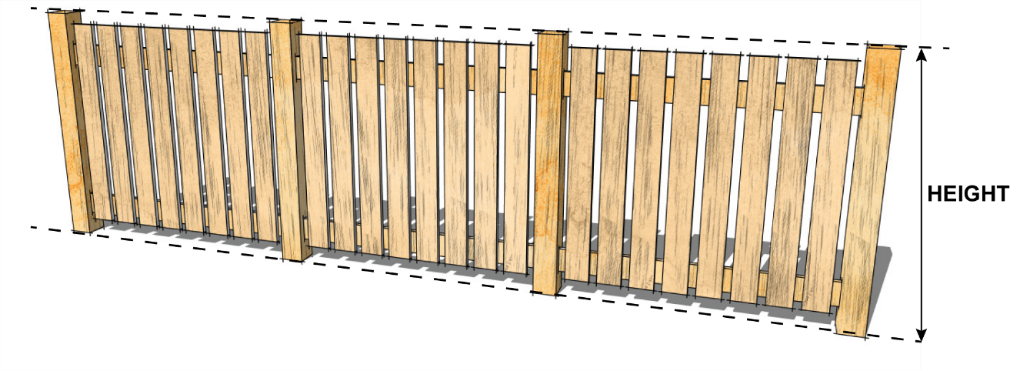
- In all ZONES, FENCES are permitted in required FRONT, REAR, or SIDE YARDS.
- In any RESIDENTIAL ZONE, a FENCE must:
- not exceed a HEIGHT of 1.22 m (4 ft.) in any required FRONT YARD.
- not exceed a HEIGHT of 1.83 m (6 ft.) in any area, including any required SIDE or REAR YARD but excluding the required FRONT YARD.
- All EXTERIOR STORAGE of goods, material, and equipment in the C1 ZONE must:
- be located to the rear or side of the PRINCIPAL BUILDING.
- be screened from view from any public roadway other than a LANE and from ADJACENT SITES in an RESIDENTIAL ZONE by FENCES, berms, landscape materials, LANDSCAPE BUFFERS or a combination of these to the satisfaction of the DEVELOPMENT OFFICER.
- not exceed a HEIGHT of 1.83 m (6 ft.) above GRADE.
- EXTERIOR STORAGE or display of goods, material, and equipment in the M1 ZONE must
- be screened from view from any public roadway other than a LANE and from adjoining SITES not in an M1 ZONE by FENCES, berms, landscape materials, or a combination of these to the satisfaction of the DEVELOPMENT OFFICER.
- not exceed a HEIGHT of 2.44 m (8 ft.) above GRADE.
- JUNKYARDS shall be completely enclosed by
- a 2.44 m (8 ft.) tall solid wooden FENCE;
- a 2.44 m (8 ft.) tall chain link FENCE with continuous hedging; or
- other screening to the satisfaction of the DEVELOPMENT OFFICER.
section 6.0
General Regulations
6.4
Height Exceptions
- The maximum HEIGHT regulations of this bylaw do not apply to the following:
- chimneystacks
- elevator housings
- flagpoles
- parapet walls
- roof stairway entrances
- skylights
- steeples
- HVAC equipment
- any other item deemed by the DEVELOPMENT OFFICER to be of a similar nature to those noted above
section 6.0
General Regulations
6.5
Heritage
- The purpose the lands located within the HERITAGE MANAGEMENT AREAS shown on Schedule C Heritage Management Map: Historic Townsite is to preserve the unique character of the HISTORIC TOWNSITE, which showcases the community’s Klondike Gold Rush era heritage, through the application of architectural guidelines.
- All DEVELOPMENT within the HERITAGE MANAGEMENT AREAS, as shown on Schedule C , shall follow the regulations outlined in the City of Dawson Design Requirements and Guidelines, in addition to those of underlaying ZONES. For example, PARCELS shown as R1 within the Residential HERITAGE MANAGEMENT AREA shall follow the regulations of the R1 ZONE as outlined in the ZONING BYLAW, as well as the regulation for the Residential HERITAGE MANAGEMENT AREA as outlined in the City of Dawson Design Requirements and Guidelines.
- The HERITAGE MANAGEMENT AREA does not apply to any Tr’ondëk Hwëch’in Settlement Lands.
section 6.0
General Regulations
6.6
Location and Siting
1. No BUILDING or STRUCTURE is permitted in a required FRONT, REAR, or SIDE YARD unless otherwise specified in this bylaw.
section 6.0
General Regulations
6.7
Setback Exceptions
The FRONT, REAR, and SIDE YARD SETBACK regulations of this bylaw do not apply to the following:
- chimneys, cornices, leaders, gutters, pilasters, belt courses, sills, bay windows, or other similar features, as determined by the DEVELOPMENT OFFICER, provided that such projections do not exceed 0.61 m (2 ft.)
- steps, eaves, canopies, decorative overhangs, balconies, or PORCHES, provided that they
- do not project more than 1.22 m (4 ft.) into a required FRONT, REAR, or exterior SIDE YARD
- do not project more than 0.61 m (2 ft.) into a required interior SIDE YARD
- steps, ramps, or boardwalks required for safe access to a PRINCIPAL BUILDING or ACCESSORY STRUCTURE due to PARCEL GRADE
- uncovered PATIOS, sundecks, or terraces, provided that they
- meet any FENCE HEIGHT requirements of this bylaw
- do not project more than 2.44 m (8 ft.) into a required FRONT YARD
- any feature that the DEVELOPMENT OFFICER approves for heritage conservation purposes, provided that it does not project into more than 10% of the required REAR or SIDE YARD.
- a SERVICE EFFICIENCY LINK in the P2 ZONE may be allowed by decision of COUNCIL when
- it has been approved by the owners of the linked BUILDINGS
- the applicant has identified the nature of the reduced operational costs created by the SERVICE EFFICIENCY LINK
- the identified reduced operational costs are in the public interest
- All roof projections, eaves, and overhangs permitted under this Section shall be designed to prevent snow, ice, and water from shedding onto ADJACENT properties, entrances, or walkways.
section 6.0
General Regulations
6.8
Water and Sewer Facilities
- No BUILDING, STRUCTURE, or land in any ZONE shall be used for any purpose where such purpose requires water and/ or sanitary sewer services unless:
- where municipal water and/or sewer infrastructure exists,
- the owner or authorized agent provides a service connection to the BUILDING or STRUCTURE at the property boundary; or
- where no municipal services exist, the owner or authorized agent provides a private water supply and sewage disposal system approved in accordance with the authority who has jurisdiction. Proof of the approval must be provided to the DEVELOPMENT OFFICER prior to the issuance of a DEVELOPMENT PERMIT.
section 7.0
Specific Use Regulations
7.1
Bed and Breakfast
Where permitted, BED AND BREAKFASTS must comply with the following regulations and meet all the requirements of all other relevant municipal bylaws:
- a BED AND BREAKFAST is only permitted within a SINGLE DETACHED DWELLING.
section 7.0
Specific Use Regulations
7.2
Boarding House
Where permitted, a BOARDING HOUSE must comply with the following regulations and meet all the requirements of all other relevant municipal bylaws:
- a BOARDING HOUSE is only permitted within a SINGLE DETACHED DWELLING.
section 7.0
Specific Use Regulations
7.3
Cannabis Retail Services
- There shall be no required SETBACKS between individual CANNABIS RETAIL SERVICE facilities.
- A CANNABIS RETAIL SERVICE shall not be located within 100 m of a SCHOOL main entrance.
- A CANNABIS RETIAL SERVICE shall be allowed to sell non-regulated goods. A Cannabis Retail Service must comply with section 17(1) of the Federal Cannabis Act when selling goods that promote cannabis.
section 7.0
Specific Use Regulations
7.4
Childcare Centres and Family Day Homes
- CHILDCARE CENTRES and FAMILY DAY HOMES shall provide documentation to the DEVELOPMENT OFFICER demonstrating that they are compliant with all appropriate federal and/or territorial legislation.
- FAMILY DAY HOMES shall follow the regulations for HOME OCCUPATIONS.
- FAMILY DAY HOMES are not permitted in MULTI-UNIT RESIDENTIAL BUILDINGS, SECONDARY SUITES, or GARDEN SUITES.
section 7.0
Specific Use Regulations
7.5
Home Industries
Where permitted, HOME INDUSTRIES must comply with the following regulations:
- A HOME INDUSTRY must be considered a SECONDARY USE to the PRINCIPAL residential use of the SITE.
- A HOME INDUSTRY must only be conducted within a DWELLING UNIT and ACCESSORY BUILDINGS.
- The HOME INDUSTRY must not occupy more than 74.3 m² (800 ft²) of the DWELLING UNIT or 25% of the total FLOOR AREA of the DWELLING UNIT, whichever is less.
- The combined FLOOR AREA of ACCESSORY BUILDINGS used for HOME INDUSTRY must not exceed 185.8 m² (2,000 ft²).
- Except in the FRONT YARD, EXTERIOR STORAGE of materials associated with the HOME INDUSTRY shall be permitted, provided that storage area:
- does not exceed 92.9 m² (1,000 ft²) and
- is enclosed by a privacy FENCE or landscaped screen to ensure that the stored materials are not visible beyond the PARCEL LINE .
- is set back at least 4.57 m (15 ft.) from any PARCEL LINE.
- A HOME INDUSTRY must not:
- create a hazardous or dangerous condition for the neighbourhood or the environment
- generate traffic congestion or parking problems for the City or the immediate neighbourhood
- produce odour, smoke, dust, or fumes beyond the PARCEL LINE
- involve materials or products that produce flammable or explosive vapours or gasses under temperature ranges common to Dawson.
- produce interference with radio, television, telephone, or other electronic or communications devices beyond the PARCEL LINE
- be used for the salvage or storage of derelict vehicles and equipment, used BUILDINGS, domestic products, and/or similar discarded materials
- permit retail sales, except for
- products incidental to a service being provided
- products produced on the SITE
- mail order sales, telephone sales, online sales, direct distributorships, or other types of sales where the customer does not enter the premises to inspect, purchase, or pick up goods
section 7.0
Specific Use Regulations
7.6
Home Occupations
Where permitted, a HOME OCCUPATION must comply with the following regulations:
- The HOME OCCUPATION must be considered a SECONDARY USE to the PRINCIPAL residential use of the BUILDING or SITE.
- Where a HOME OCCUPATION is proposed in a SECONDARY SUITE or GARDEN SUITE, consent from the PRINCIPAL residential users may be required prior to permit approval.
- Other than an authorized sign, no exterior evidence of a HOME OCCUPATION is permitted to be visible on the SITE on which the HOME OCCUPATION is located.
- For the purposes of this section, the presence of a GARDEN and/or GREENHOUSE shall not be deemed to be exterior evidence of a HOME OCCUPATION.
- No EXTERIOR STORAGE of materials associated with a HOME OCCUPATION is permitted.
- There shall be no manner of use or noise of an offensive or objectionable nature to interfere with the peaceful and quiet enjoyment of neighbouring properties, to the satisfaction of the DEVELOPMENT OFFICER.
section 7.0
Specific Use Regulations
7.7
Greenhouses
GREENHOUSES are permitted as a SECONDARY USE in all ZONES, provided that they comply with all regulations for ACCESSORY BUILDINGS and STRUCTURES laid out in this bylaw.
section 7.0
Specific Use Regulations
7.8
Parks and Natural Space
- PARKS and NATURAL SPACE are permitted in all ZONES.
section 7.0
Specific Use Regulations
7.9
Public Utilities
- Public utility facilities for the distribution of water, sewage, electrical power, telephone, cable television, and other similar services are permitted in all ZONES.
- This does not include LANDFILLS and waste treatment facilities, sewage treatment plants, LAGOONS, or ELECTRICAL SUBSTATIONS which have been identified as CONDITIONAL USES.
- Permanent electrical power is permitted only if it is required to support an approved, permanent use on a PARCEL.
- Individual PARCELS for public utility facilities are exempt from minimum PARCEL area requirements.
- All changes and new installations of a public utility must have a valid DEVELOPMENT PERMIT.
section 7.0
Specific Use Regulations
7.10
Reclamation, Remediation and Land Development Preparation
- RECLAMATION of former NATURAL RESOURCE DEVELOPMENT SITES, LAND DEVELOPMENT PREPARATION, and REMEDIATION of land containing contaminated material is permitted in all ZONES.
- All RECLAMATION, REMEDIATION and LAND DEVELOPMENT PREPARATION activity must have a valid DEVELOPMENT PERMIT.
- Upon abandonment or termination of resource extraction operations, the remaining redevelopment and RECLAMATION of the SITE shall begin immediately and be carried out in cooperation with the appropriate authorities.
- RECLAMATION shall be done to as natural a state as possible through slope grading, LANDSCAPING, and reforestation, or to another productive state and/or use in line with the OFFICIAL COMMUNITY PLAN.
- Prior to RECLAMATION, the RECLAMATION plan may be revisited to determine if an alternate use is feasible.
- For activities authorized under the Placer Mining Act, all RECLAMATION activity must have a valid Placer Land Use Approval and Water License, if applicable.
section 7.0
Specific Use Regulations
7.11
Secondary and Garden Suites
- .SECONDARY SUITES must comply with the following regulations:
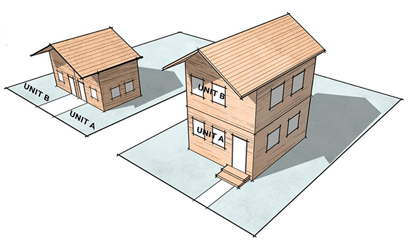
- a SECONDARY SUITE is only permitted as a SECONDARY USE within a SINGLE DETACHED DWELLING or DUPLEX.
- SECONDARY SUITES shall have a FLOOR AREA lesser than or equal to the FLOOR AREA of the PRINCIPAL USE it is located in.
- a maximum of one SECONDARY SUITE is permitted per DWELLING UNIT of its PRINCIPAL USE.
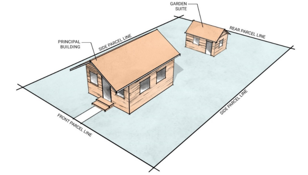
- GARDEN SUITES must comply with the following regulations:
- A GARDEN SUITE is only permitted within an ACCESSORY BUILDING on the same PARCEL as a PRINCIPAL USE.
- A GARDEN SUITE can be up to 100% of the FLOOR AREA of the ACCESSORY BUILDING.
- GARDEN SUITES located on PARCELS connected to municipal servicing must be connected to municipal servicing.
- The maximum number of GARDEN SUITES permitted per PARCEL is at the discretion of the DEVELOPMENT OFFICER and shall consider connection to municipal infrastructure, PARCEL size, and ability to providing sufficient parking spaces.
- At the discretion of the DEVELOPMENT OFFICER, a GARDEN SUITE may be constructed prior to the PARCEL’s PRINCIPAL USE a single detached dwelling, subject to the following criteria:
- A GARDEN SUITE is to be constructed in an ACCESSORY BUILDING only; as such, a DEVELOPMENT PERMIT must be submitted and approved that shows details for both the PRINCIPAL BUILDING and ACCESSORY BUILDING.
- The DEVELOPMENT PERMIT must include a time limit that dictates how long the GARDEN SUITE can exist without the construction of the PRINCIPAL BUILDING.
- The placement of the GARDEN SUITE must allow for sufficient space to construct the PRINCIPAL BUILDING.
- The GARDEN SUITE must meet all other regulations for a SINGLE DETACHED DWELLING as a stand-alone STRUCTURE.
- A SECONDARY SUITE is not permitted on PARCELS with a BED AND BREAKFAST.
- One additional parking space must be provided on the PARCEL for each additional DWELLING UNIT created through the development of a SECONDARY SUITE or GARDEN SUITE, in addition to the parking required for the PRINCIPAL USE, unless waived under the Development Incentive Policy.
- At the discretion of the DEVELOPMENT OFFICER, a GARDEN SUITE may be constructed: with up to two DWELLING UNITS, subject to the following criteria:
- the GARDEN SUITE has a FLOOR AREA lesser than the FLOOR AREA of the PRINCIPAL USE on the PARCEL.
- sufficient parking can be provided, to the satisfaction of the DEVELOPMENT APPROVING AUTHORITY.
- the creation of a CONDOMINIUM PARCEL pursuant to the Condominium Act and Regulations for a SECONDARY SUITE or GARDEN SUITE shall not be permitted.
section 7.0
Specific Use Regulations
7.12
Service Stations
Where permitted, SERVICE STATIONS must conform to the following provisions:
- Pump island storage tanks and related accessories must meet the requirements of all relevant federal and territorial legislation.
- All repair equipment shall be kept, and all repair work shall be done, entirely within the BUILDING or in the maintenance YARD.
- All exterior lighting must deflect away from ADJACENT PARCELS.
- A minimum 1.83 m (6 ft.) FENCE must be provided on all PARCEL lines separating the PARCEL from any ABUTTING RESIDENTIAL ZONE.
section 7.0
Specific Use Regulations
7.13
Vendors
- For the purpose of this bylaw, vendors include both commercial and food vendors.
- Vendors are intended to provide short- term or SEASONAL services using equipment that may be dismantled and removed from the SITE from time to time.
- Vendors shall be responsible for the following, at their own expense:
- complying with all statutes, regulations, and bylaws whether federal, territorial, or municipal
- obtaining all licenses and permits required
- the supply and maintenance of garbage receptacles and disposal of garbage to an approved disposal SITE
- maintaining the lands in the vicinity of their operation in a clean, litter-free, and tidy state
- not interfering with the quiet use and enjoyment of the surrounding areas by the public
- supplying proof of valid public liability insurance, to the amount of two (2) million dollars, when located on lands owned by the City
- Each vendor shall apply to the City for permission to operate using a DEVELOPMENT PERMIT for TEMPORARY USE as outlined in Section 4.8 Considerations for Specific Types of Permits.
- Mobile vendors shall be limited to:
- a mobile refreshment stand completely contained within a trailer, a motorized vehicle, a bicycle, a push-cart, an approved container, or some other non-mechanized means.
- a temporary commercial operation completely contained within a trailer, a motorized vehicle, a bicycle, a push-cart, an approved container, or some other non-mechanized means.
- Vendors shall not be permitted anywhere other than the SITE specified in the City’s approval.
- Temporary electrical hook-up shall be allowed, subject to the vendor stall meeting all applicable codes and regulations.
- The City may inspect any vendor facility to ensure compliance with this policy. If non-compliance is found, the City has the right to revoke the approval for such use. Ongoing operation of a Development Permit for TEMPORARY USE shall not be inferred as a right or entitlement.
section 8.0
Parking and Loading
8.1
Existing Building and Structures
- No off-street parking requirements contained in this section shall apply to BUILDINGS, STRUCTURES, or USES existing on the effective date of this bylaw except the following:
- Off-street parking shall be provided and maintained in accordance with this section for any ADDITION to such existing BUILDINGS or STRUCTURES, or any change or ADDITION to such use.
- Off-street parking existing on the effective date of this bylaw shall not be reduced below the applicable off-street parking requirements of this section.
section 8.0
Parking and Loading
8.2
Cash in Lieu of Onsite Parking and Loading
- Table 8-1 outlines the required number of off-street parking spaces required for each type of BUILDING.
- Table 8-2 outlines the required number of off-street LOADING SPACES required for each type of BUILDING.
- Where a proposed use is not listed, the off-street parking spaces required will be determined by the DEVELOPMENT OFFICER through an evaluation of the proposed USE and comparison to those contemplated in Table 8-1.
- When the calculation of the required off-street parking spaces or LOADING SPACES results in a fraction, the calculation shall be rounded up to the nearest whole number.
- Except where cash in lieu is provided in accordance with City bylaws, the required off street parking and LOADING SPACES shall be located on the same PARCEL as the BUILDING they serve or on a separate PARCEL within 152.4 m (500 ft.) of the BUILDING and must be registered as an easement.
- In the case of a MIXED-USE DEVELOPMENT, the number of off-street parking spaces required shall be the sum of the off-street parking space requirements for each use.
- A reduction in parking requirements may be permitted based on applicable development incentives or other, at the discretion of the DEVELOPMENT OFFICER.
Table 8-1: REQUIRED OFF-STREET PARKING SPACES
RESIDENTIAL USES
USE
SINGLE DETACHED DWELLING and DUPLEX (4 bedrooms or less)
REQUIRED PARKING SPACES
1 per DWELLING UNIT
USE
SINGLE DETACHED DWELLING and DUPLEX (over 4 bedrooms)
REQUIRED PARKING SPACES
2 per DWELLING UNIT
USE
MULTI-UNIT RESIDENTIAL
REQUIRED PARKING SPACES
0.8 per DWELLING UNIT
USE
BED AND BREAKFAST
REQUIRED PARKING SPACES
1 per 2 bedrooms available for rent (in addition to the space required for the residential use)
USE
SECONDARY SUITE or GARDEN SUITE
REQUIRED PARKING SPACES
1 per DWELLING UNIT
USE
TEMPORARY SHELTER SERVICES
REQUIRED PARKING SPACES
1 per every 2 SLEEPING UNITS
USE
REQUIRED PARKING SPACES
SINGLE DETACHED DWELLING and DUPLEX (4 bedrooms or less)
1 per DWELLING UNIT
SINGLE DETACHED DWELLING and DUPLEX (over 4 bedrooms)
2 per DWELLING UNIT
MULTI-UNIT RESIDENTIAL
0.8 per DWELLING UNIT
BED AND BREAKFAST
1 per 2 bedrooms available for rent (in addition to the space required for the residential use)
SECONDARY SUITE or GARDEN SUITE
1 per DWELLING UNIT
TEMPORARY SHELTER SERVICES
1 per every 2 SLEEPING UNITS
INSTITUTIONAL USES
USE
HEALTH CARE FACILITY
REQUIRED PARKING SPACES
1 per 100 m² (1,076 ft²) of FLOOR AREA
USE
SCHOOL
REQUIRED PARKING SPACES
1 per 2 classrooms
USE
AMUSEMENT ESTABLISHMENT, COMMUNITY RECREATION FACILITY, EXHIBITION AND CONVENTION FACILITIES, LIBRARY, MUSEUM, RELIGIOUS ASSEMBLY FACILITY
REQUIRED PARKING SPACES
2 per 100 m² of FLOOR AREA for BUILDINGS less than 2,000m²; 3 per 100 m² of FLOOR AREA for BUILDINGS between 2,000 – 20,000 m²; 4 per 100 m² for BUILDINGS over 20,000 m²;
USE
CHILDCARE CENTRE
REQUIRED PARKING SPACES
1 parking stall per 8 children
USE
REQUIRED PARKING SPACES
HEALTH CARE FACILITY
1 per 100 m² (1,076 ft²) of FLOOR AREA
SCHOOL
1 per 2 classrooms
AMUSEMENT ESTABLISHMENT, COMMUNITY RECREATION FACILITY, EXHIBITION AND CONVENTION FACILITIES, LIBRARY, MUSEUM, RELIGIOUS ASSEMBLY FACILITY
2 per 100 m² of FLOOR AREA for BUILDINGS less than 2,000m²; 3 per 100 m² of FLOOR AREA for BUILDINGS between 2,000 – 20,000 m²; 4 per 100 m² for BUILDINGS over 20,000 m²;
CHILDCARE CENTRE
1 parking stall per 8 children
COMMERCIAL USES
USE
OFFICE or OFFICE SUPPORT SERVICE
REQUIRED PARKING SPACES
1 per 100 m² (1,076 ft²) of FLOOR AREA
USE
PERSONAL SERVICE ESTABLISHMENT
REQUIRED PARKING SPACES
1per 100 m² (1,076 ft²) of FLOOR AREA
USE
RETAIL STORE, CONVENIENCE STORE, and GROCERY STORE
REQUIRED PARKING SPACES
1 per 100 m² (1,076 ft²) of FLOOR AREA
USE
HOUSEHOLD REPAIR SERVICE, VEHICLE SALES AND SERVICE
REQUIRED PARKING SPACES
1 per 150 m² (1,615 ft²) of FLOOR AREA
USE
EATING AND DRINKING ESTABLISHMENT, MICROBREWERY/ CRAFT DISTILLERY
REQUIRED PARKING SPACES
1 per 100 m² (1,076 ft²) of FLOOR AREA
USE
HOTEL
REQUIRED PARKING SPACES
1 per every 4 DWELLING UNIT or SLEEPING UNIT with bus stall; 1 per every 2 DWELLING UNIT or SLEEPING UNIT without bus stall
USE
MOTEL
REQUIRED PARKING SPACES
1 per DWELLING UNIT or SLEEPING UNIT
USE
LODGING FACILITY
REQUIRED PARKING SPACES
1 per DWELLING UNIT or SLEEPING UNIT
USE
LAUNDROMAT
REQUIRED PARKING SPACES
1 per 4 washing machines
USE
CAMPGROUND
REQUIRED PARKING SPACES
1 per camping SITE + 1 space for the operator
USE
REQUIRED PARKING SPACES
OFFICE or OFFICE SUPPORT SERVICE
1 per 100 m² (1,076 ft²) of FLOOR AREA
PERSONAL SERVICE ESTABLISHMENT
1per 100 m² (1,076 ft²) of FLOOR AREA
RETAIL STORE, CONVENIENCE STORE, and GROCERY STORE
1 per 100 m² (1,076 ft²) of FLOOR AREA
HOUSEHOLD REPAIR SERVICE, VEHICLE SALES AND SERVICE
1 per 150 m² (1,615 ft²) of FLOOR AREA
EATING AND DRINKING ESTABLISHMENT, MICROBREWERY/ CRAFT DISTILLERY
1 per 100 m² (1,076 ft²) of FLOOR AREA
HOTEL
1 per every 4 DWELLING UNIT or SLEEPING UNIT with bus stall; 1 per every 2 DWELLING UNIT or SLEEPING UNIT without bus stall
MOTEL
1 per DWELLING UNIT or SLEEPING UNIT
LODGING FACILITY
1 per DWELLING UNIT or SLEEPING UNIT
LAUNDROMAT
1 per 4 washing machines
CAMPGROUND
1 per camping SITE + 1 space for the operator
INDUSTRIAL USES
USE
CONTRACTOR SERVICES or public works YARD
REQUIRED PARKING SPACES
1 per 250 m² (2,691 ft²) of FLOOR AREA
USE
EQUIPMENT SALES, RENTALS AND SERVICE
REQUIRED PARKING SPACES
1 per 250 m² (2,691 ft²) of FLOOR AREA
USE
WAREHOUSING
REQUIRED PARKING SPACES
1 per 250 m² (2,691 ft²) of FLOOR AREA
USE
VEHICLE SALES, RENTALS AND SERVICES
REQUIRED PARKING SPACES
1 per 250 m² (2,691 ft²) of FLOOR AREA + 1 per service bay
USE
MANUFACTURING
REQUIRED PARKING SPACES
1 per 250 m² (2,691 ft²) of FLOOR AREA
USE
REQUIRED PARKING SPACES
CONTRACTOR SERVICES or public works YARD
1 per 250 m² (2,691 ft²) of FLOOR AREA
EQUIPMENT SALES, RENTALS AND SERVICE
1 per 250 m² (2,691 ft²) of FLOOR AREA
WAREHOUSING
1 per 250 m² (2,691 ft²) of FLOOR AREA
VEHICLE SALES, RENTALS AND SERVICES
1 per 250 m² (2,691 ft²) of FLOOR AREA + 1 per service bay
MANUFACTURING
1 per 250 m² (2,691 ft²) of FLOOR AREA
Table 8-2: REQUIRED OFF-STREET LOADING SPACES
CLASS OF BUILDING
Retail store, MANUFACTURING, fabricating, processing, WAREHOUSING, and wholesaling establishment
REQUIRED PARKING SPACES
CLASS OF BUILDING
Less than 2,000.02 m² (21,528 ft²) in FLOOR AREA
REQUIRED PARKING SPACES
1
CLASS OF BUILDING
2,000.02 (21,528 ft²) to 4,000.03 m² (43,056 ft²) in FLOOR AREA
REQUIRED PARKING SPACES
2
CLASS OF BUILDING
Greater than 4,000.03 m² (43,056 ft²) in FLOOR AREA
REQUIRED PARKING SPACES
3
CLASS OF BUILDING
REQUIRED PARKING SPACES
Retail store, MANUFACTURING, fabricating, processing, WAREHOUSING, and wholesaling establishment
Less than 2,000.02 m² (21,528 ft²) in FLOOR AREA
1
2,000.02 (21,528 ft²) to 4,000.03 m² (43,056 ft²) in FLOOR AREA
2
Greater than 4,000.03 m² (43,056 ft²) in FLOOR AREA
3
section 8.0
Parking and Loading
8.3
Cash in Lieu of Onsite Parking and Loading
- Where the requirements for parking space cannot be met, the owner and the City may enter into an agreement to provide cash in lieu of onsite parking.
- COUNCIL shall establish each year, through the Fees and Charges Bylaw, as amended, the value of one onsite parking stall and one onsite LOADING SPACES. In establishing the value, COUNCIL shall consider the cost of providing such a parking or LOADING SPACES, including the cost of replacement land and improvements.
- Notwithstanding any agreement made under s.10.3.1, the City is under no obligation to provide or construct the equivalent number of parking or LOADING SPACES for which cash in lieu has been accepted. The acceptance of cash in lieu does not guarantee the availability of public parking or loading in the vicinity of the DEVELOPMENT.
section 8.0
Parking and Loading
8.4
Dimensions and Access to Parking and Loading Spaces
- Each off-street parking space required by this bylaw shall not be less than 2.74 m (9 ft.) wide or 6.10 m (20 ft.) long, or have a vertical clearance less than 2.29 m (7.5 ft.).
- LOADING SPACES shall be of adequate size as determined by the DEVELOPMENT OFFICER and have an access that accommodates the types of vehicles that will be loading and unloading without those vehicles projecting into a public roadway.
- In no case shall the space be less than 27.87 m² (300 ft²) or less than 2.74 m (9 ft.) wide or have less than 3.66 m (12 ft.) overhead clearance.
- Within the downtown core area, where a PARCEL has access to a rear LANE, all vehicle access to parking and LOADING SPACES must be provided from the rear LANE. Where a bus stall is provided it shall be clearly marked “Buses” and that parking stall shall be not less than 3.66 m (12 ft.) wide or 15.24 m (50 ft.) long or have a clearance of less than 3.66 m (12 ft.).
- Design of off-street parking
- Every application for off-street parking of three or more vehicles shall clearly delineate individual parking spaces, LOADING SPACES, spaces for universal accessibility, maneuvering aisles, entrances, and exits.
- Spaces intended for loading and universal accessibility must include signage or other means of identification.
- Every off-street parking or loading area, and access thereto, shall have methods to prevent vehicles from encroaching upon ADJACENT properties or encumber other lands other than the subject property which includes consideration for access in/ out of the parking areas and how headlights may impact ABUTTING residents.
- Every off-street parking or loading area which is illuminated shall have all lighting positioned in such a manner that light falling onto ABUTTING properties is minimized.
section 9.0
Signs
9.1
General Sign Provisions
- No SIGN shall be erected within the city except those provided for in this bylaw.
- A DEVELOPMENT PERMIT is required for the erection, display, alteration, replacement, or relocation of all SIGNS if located within the HISTORIC TOWNSITE, excluding those listed in Section 9.3 Signs Not Requiring a Development Permit.
- No SIGN shall be erected that interferes with traffic or the visibility of a traffic control device.
- All SIGNS must be erected or applied in such a manner as to reflect the City of Dawson Design Requirements and Guidelines and the Heritage Management Plan if located in the HISTORIC TOWNSITE.
- No SIGN shall exceed the maximum permissible HEIGHT for an ACCESSORY BUILDING or STRUCTURE in the ZONE in which the SIGN is located.
- No PARCEL shall have more than two (2) FREE-STANDING, PORTABLE, or BILLBOARD SIGNS in total.
- All SIGNS, including attaching and support STRUCTURES, shall be maintained in good and safe structural condition.
- No SIGN shall shine, reflect, or emit light in a manner that adversely affects ADJACENT or ABUTTING residential properties.
- No SIGNS shall display intolerance, hatred, or ridicule toward any race, religion, or other identifiable group of people, or that otherwise fail to meet the requirements outlined in the Canadian Code of Advertising Standards.
section 9.0
Signs
9.2
Sign Specific Regulations
Table 9-1 SIGN TYPES AND REGULATIONS
A-FRAME SIGN
DEFINITION
A temporary, self-supported freestanding SIGN typically placed on the ground and set out daily, also known as a sandwich board.
REGULATIONS
2. A-FRAME SIGNS shall:
-
- Not exceed 1.0 m (3.28 ft.)in HEIGHT.
- Only be displayed during the operating hours of the business to which it refers
- Not be placed more than 300 m (984.3 ft.) from the business it is advertising.
A-FRAME SIGN
DEFINITION
REGULATIONS
A temporary, self-supported freestanding SIGN typically placed on the ground and set out daily, also known as a sandwich board.
2. A-FRAME SIGNS shall:
-
- Not exceed 1.0 m (3.28 ft.)in HEIGHT.
- Only be displayed during the operating hours of the business to which it refers
- Not be placed more than 300 m (984.3 ft.) from the business it is advertising.
AWNING/ CANOPY SIGN
DEFINITION
A SIGN that forms part of or is attached to a retractable or permanently affixed canopy STRUCTURE. It may also include a SIGN suspended below the ceiling or roof of the canopy.
REGULATIONS
3. AWNING/CANOPY SIGNS shall:
-
- maintain a minimum vertical clearance of 2.5 m between the bottom of the canopy or awning and a walkway or ground level
- not project over a curb or street
AWNING/ CANOPY SIGN
DEFINITION
REGULATIONS
A SIGN that forms part of or is attached to a retractable or permanently affixed canopy STRUCTURE. It may also include a SIGN suspended below the ceiling or roof of the canopy.
3. AWNING/CANOPY SIGNS shall:
-
- maintain a minimum vertical clearance of 2.5 m between the bottom of the canopy or awning and a walkway or ground level
- not project over a curb or street
BANNER SIGN
DEFINITION
A TEMPORARY SIGN constructed of a non-rigid material on which a message is displayed marketing an event, business, or product
REGULATIONS
4. BANNER SIGNS shall:
-
- not exceed 14.4 m² or 155 ft²
BANNER SIGN
DEFINITION
REGULATIONS
A TEMPORARY SIGN constructed of a non-rigid material on which a message is displayed marketing an event, business, or product
4. BANNER SIGNS shall:
-
- not exceed 14.4 m² or 155 ft²
BILLBOARD SIGN
DEFINITION
A SIGN located primarily along major traffic corridors that advertises goods, products, services, or events offered at a different location from where the SIGN is installed.
REGULATIONS
5. BILLBOARD SIGNS shall:
-
- Not exceed 14.4 m² or 155 ft²
BILLBOARD SIGN
DEFINITION
REGULATIONS
A SIGN located primarily along major traffic corridors that advertises goods, products, services, or events offered at a different location from where the SIGN is installed.
5. BILLBOARD SIGNS shall:
-
- Not exceed 14.4 m² or 155 ft²
FASCIA/WALL SIGN
DEFINITION
A SIGN attached to the exterior face of a BUILDING, mounted flush and running parallel to the BUILDING‘s surface. Does not include a PAINTED WALL SIGN, PROJECTING SIGN or MURAL.
REGULATIONS
6. FASCIA/WALL SIGNS shall:
-
- Not project more than 0.30 m from the BUILDING face or SIGN STRUCTURE to which it is attached.
FASCIA/WALL SIGN
DEFINITION
REGULATIONS
A SIGN attached to the exterior face of a BUILDING, mounted flush and running parallel to the BUILDING‘s surface. Does not include a PAINTED WALL SIGN, PROJECTING SIGN or MURAL.
6. FASCIA/WALL SIGNS shall:
-
- Not project more than 0.30 m from the BUILDING face or SIGN STRUCTURE to which it is attached.
FREE STANDING
DEFINITION
A self-supporting SIGN permanently fixed to the ground and visibly separated from a BUILDING which is directly related to the use of the PARCEL it is located on.
REGULATIONS
7. FREE STANDING SIGNS shall:
-
- not exceed 3 m² or 32.2ft²
FREE STANDING
DEFINITION
REGULATIONS
A self-supporting SIGN permanently fixed to the ground and visibly separated from a BUILDING which is directly related to the use of the PARCEL it is located on.
7. FREE STANDING SIGNS shall:
-
- not exceed 3 m² or 32.2ft²
PAINTED WALL SIGN
DEFINITION
A SIGN painted on or applied directly as film to an exterior wall.
REGULATIONS
8. PAINTED WALL SIGNS:
-
- shall be used to advertise the business or use within the BUILDING upon which it is applied on.
- may be part of a MURAL
PAINTED WALL SIGN
DEFINITION
REGULATIONS
A SIGN painted on or applied directly as film to an exterior wall.
8. PAINTED WALL SIGNS:
-
- shall be used to advertise the business or use within the BUILDING upon which it is applied on.
- may be part of a MURAL
PORTABLE SIGN
DEFINITION
A TEMPORARY SIGN mounted on a frame, trailer, or stand that is not permanently attached to the ground and can be easily moved to different locations.
REGULATIONS
9. PORTABLE SIGNS shall:
-
- not exceed 3 m² or 32.2 ft²
PORTABLE SIGN
DEFINITION
REGULATIONS
A TEMPORARY SIGN mounted on a frame, trailer, or stand that is not permanently attached to the ground and can be easily moved to different locations.
9. PORTABLE SIGNS shall:
-
- not exceed 3 m² or 32.2 ft²
PROJECTING SIGN
DEFINITION
A SIGN other than FASCIA/WALL SIGN OR CANOPY SIGN that is attached to a BUILDING and projects more than 0.4 m from the face of a BUILDING wall or STRUCTURE.
REGULATIONS
10. PROJECTING SIGNS shall:
-
- be a maximum of 2.8 m² or 30.1 ft².
- not extend more than 2.0 m from the face of the BUILDING
- maintain a minimum vertical clearance of 2.5 m between the bottom of the projecting SIGN and a walkway or ground level.
PROJECTING SIGN
DEFINITION
REGULATIONS
A SIGN other than FASCIA/WALL SIGN OR CANOPY SIGN that is attached to a BUILDING and projects more than 0.4 m from the face of a BUILDING wall or STRUCTURE.
10. PROJECTING SIGNS shall:
-
- be a maximum of 2.8 m² or 30.1 ft².
- not extend more than 2.0 m from the face of the BUILDING
- maintain a minimum vertical clearance of 2.5 m between the bottom of the projecting SIGN and a walkway or ground level.
ROOF SIGN
DEFINITION
A SIGN erected upon, against or directly above a roof or on top of or above the parapet wall of a BUILDING
REGULATIONS
11. ROOF SIGNS shall:
-
- be a maximum of 4.0 m² or 43 ft².
- not exceed the maximum HEIGHT of the applicable zone.
ROOF SIGN
DEFINITION
REGULATIONS
A SIGN erected upon, against or directly above a roof or on top of or above the parapet wall of a BUILDING
11. ROOF SIGNS shall:
-
- be a maximum of 4.0 m² or 43 ft².
- not exceed the maximum HEIGHT of the applicable zone.
section 9.0
Signs
9.3
Signs Not Requiring a Development Permit
- A SIGN located outside of the HISTORIC TOWNSITE, provided that such SIGN conforms to all other provisions of this bylaw.
- An operational SIGN as required by a level of government, to be placed on public property such as traffic signs, street signs, interpretive monuments, historic plaques, park entry features, etc.
- Wayfinding SIGN authorized by the DEVELOPMENT OFFICER or COUNCIL.
- A community-oriented SIGN and/or public service banner SIGN, authorized by the DEVELOPMENT OFFICER or COUNCIL, provided it does not interfere with traffic or the visibility of a traffic control device.
- A MURAL, authorized by COUNCIL, provided it complies with the HERITAGE MANAGEMENT PLAN.
- A TEMPORARY SIGN that advertises a lawn sale, garage sale, real estate sale, or other special community event up to 1 m² (10.8 ft²).
- Campaign SIGNS for elections which may be placed on private property only after an election has been officially called. These SIGNS must be removed no later than seven (7) days after the election concludes, unless otherwise specified by governmental regulations.
- SIGNS located on SITE(s) where construction, operation, and/or maintenance is occurring, where:
- The SIGN is placed after construction has commenced and must be removed within sixty (60) days of s construction completion.
section 10.0
Residential Zones
10.1
R1 Zone (Small-Scale Multi-Unit Housing)
The purpose of the R1 zone is to permit a range of small-scale DWELLING UNITS which provide a variety of housing types while maintaining a low-density residential atmosphere.
10.1.1
Principal Uses
The following use(s) may be considered permitted as PRINCIPAL USES in the R1 zone:
- BOARDING HOUSE
- DUPLEX
- SINGLE DETACHED DWELLING
- TEMPORARY SHELTER SERVICES
10.1.2
Secondary Uses
The following use(s) may be considered secondary to a PRINCIPAL USE in the R1 zone:
- ACCESSORY BUILDING OR STRUCTURE
- BED AND BREAKFAST
- FAMILY DAY HOME
- GARDEN SUITE
- HOME OCCUPATION
- SECONDARY SUITE
10.1.3
Zone-Specific Regulations
- On a PARCEL located in an area zoned R1:
- a maximum of one PRINCIPAL BUILDING is permitted per PARCEL
- that is not serviced by a municipal sanitary sewer or water system,
- the owner or authorized agent shall provide a private water supply and sewage disposal system approved in accordance with the authority who has jurisdiction. Proof of the approval must be provided to the DEVELOPMENT OFFICER prior to the issuance of a DEVELOPMENT PERMIT
- Proof of an approved sewage system disposal permit from the Government of Yukon must be provided to the DEVELOPMENT OFFICER prior to issuance of a DEVELOPMENT PERMIT.
- a maximum of two DWELLING UNITS per PARCEL is permitted, unless proof of capacity of private water supply and sewage disposal system to support additional dwellings is provided to the DEVELOPMENT OFFICER’s satisfaction.
- the MINIMUM PARCEL SIZE, width, and SETBACKS shall be determined by the DEVELOPMENT OFFICER to ensure compliance with the Yukon Public Health and Safety Act, Sewage Disposal Systems Regulation regarding sewage disposal system siting.
- that is serviced by a municipal sanitary sewer system:
- no more than four DWELLING UNITS shall be permitted per PARCEL, through any combination of dwelling types
- no plan of subdivision shall be approved in such a way that contravenes the regulations set out in the table below unless Section 5.1.4 or 5.1.5 applies, and
- no BUILDING or STRUCTURE shall be constructed, altered, or located in such a way that contravenes the regulations set out in Table 10–1, in which column 1 sets out the matter to be regulated and column 2 sets out the regulations.
Table 10-1: R1 ZONE MINIMUM PARCEL REQUIREMENTS
MNIMUM PARCEL SIZE
232.3 m² (2,500 ft²)
Minimum PARCEL width
7.6 m (25 ft.)
Minimum SETBACK of BUILDINGS from
front PARCEL line
2.00 m (6.56 ft.)
interior side PARCEL line
for a dwelling
for a dwelling 1.52 m (5 ft.)
for a non-dwelling ACCESSORY BUILDING
0.61 m (2 ft.)
for a DUPLEX with a shared wall on PARCEL line
0 m (0 ft.)
for a GARAGE
1.52 m (5 ft.)
exterior side PARCEL line
1.52 m (5 ft.)
for ACCESSORY BUILDINGS or STRUCTURES
1.52 m (5 ft.)
rear PARCEL line
3.05 m (10 ft.)
for ACCESSORY BUILDINGS or STRUCTURES
0.61 m
other BUILDINGS
for a dwelling to dwelling
1.52 m (5 ft.)
for a dwelling to non-dwelling
0.61 m (2 ft.)
for a non-dwelling to non-dwelling
0.61 m
Maximum PARCEL coverage
70%
Maximum HEIGHT for
PRINCIPAL BUILDING
10.67 m (35 ft.)
ACCESSORY BUILDING
6.10 m (20 ft.)
Column 1
Column 2
MNIMUM PARCEL SIZE
232.3 m² (2,500 ft²)
Minimum PARCEL width
7.6 m (25 ft.)
Minimum SETBACK of BUILDINGS from
front PARCEL line
2.00 m (6.56 ft.)
interior side PARCEL line
for a dwelling
for a dwelling 1.52 m (5 ft.)
for a non-dwelling ACCESSORY BUILDING
0.61 m (2 ft.)
for a DUPLEX with a shared wall on PARCEL line
0 m (0 ft.)
for a GARAGE
1.52 m (5 ft.)
exterior side PARCEL line
1.52 m (5 ft.)
for ACCESSORY BUILDINGS or STRUCTURES
1.52 m (5 ft.)
rear PARCEL line
3.05 m (10 ft.)
for ACCESSORY BUILDINGS or STRUCTURES
0.61 m
other BUILDINGS
for a dwelling to dwelling
1.52 m (5 ft.)
for a dwelling to non-dwelling
0.61 m (2 ft.)
for a non-dwelling to non-dwelling
0.61 m
Maximum PARCEL coverage
70%
Maximum HEIGHT for
PRINCIPAL BUILDING
10.67 m (35 ft.)
ACCESSORY BUILDING
6.10 m (20 ft.)
section 10.0
Residential Zones
10.2
R2 Zone (Multi‐Unit Residential)
- The purpose of the R2 zone is to permit multi-unit residential development in appropriate locations.
10.2.1
Principal Uses
The following use(s) may be considered permitted as PRINCIPAL USES in the R2 zone:
- MULTI‐UNIT RESIDENTIAL
- TEMPORARY SHELTER SERVICES
- TOWNHOUSE
10.2.2
Secondary Uses
The following use(s) may be considered secondary to a PRINCIPAL USE in the R2 zone.
- ACCESSORY BUILDING or STRUCTURE
- HOME OCCUPATION
10.2.3
Zone-Specific Regulations
- On a PARCEL located in an area zoned R2:
- no plan of subdivision shall be approved in such a way that contravenes the regulations set out in the table below unless Section 5.1.4 or 5.1.5 applies
- and no BUILDING or STRUCTURE shall be constructed, altered, or located in such a way that contravenes the regulations set out in Table 10-2 below, in which column 1 sets out the matter to be regulated and column 2 sets out the regulations.
Table 10-2: R2 ZONE MINIMUM PARCEL REQUIREMENTS
Minimum PARCEL SIZE
464.5 m² | (5,000 ft²)
Minimum PARCEL width
15.24 m | (50 ft.)
Minimum SETBACK of BUILDINGS from
front PARCEL line
3.05 m | (10 ft.)
interior side PARCEL line
1.52 m | (5 ft.)
for a MULTI-UNIT RESIDENTIAL DEVELOPMENT or TOWNHOUSE with a shared wall on PARCEL LINE
0.00 m | (0 ft.)
exterior side PARCEL line
3.05 m | (10 ft.)
rear PARCEL line
1.52 | (5 ft.)
for ACCESSORY BUILDINGS or STRUCTURES
0.61 m | (2 ft.)
other BUILDINGS
for a dwelling to dwelling
3.05 m | (10 ft.)
for a dwelling to non-dwelling
1.52 m | (5 ft.)
for a non-dwelling to non-dwelling
0.61 m | (2 ft.)
Maximum PARCEL coverage
70%
Maximum HEIGHT for
PRINCIPAL BUILDING
10.67 m | (35 ft.)
ACCESSORY BUILDING
6.10 m | (20 ft.)
Column 1
Column 2
Minimum PARCEL SIZE
464.5 m² | (5,000 ft²)
Minimum PARCEL width
15.24 m | (50 ft.)
Minimum SETBACK of BUILDINGS from
front PARCEL line
3.05 m | (10 ft.)
interior side PARCEL line
1.52 m | (5 ft.)
for a MULTI-UNIT RESIDENTIAL DEVELOPMENT or TOWNHOUSE with a shared wall on PARCEL LINE
0.00 m | (0 ft.)
exterior side PARCEL line
3.05 m | (10 ft.)
rear PARCEL line
1.52 | (5 ft.)
for ACCESSORY BUILDINGS or STRUCTURES
0.61 m | (2 ft.)
other BUILDINGS
for a dwelling to dwelling
3.05 m | (10 ft.)
for a dwelling to non-dwelling
1.52 m | (5 ft.)
for a non-dwelling to non-dwelling
0.61 m | (2 ft.)
Maximum PARCEL coverage
70%
Maximum HEIGHT for
PRINCIPAL BUILDING
10.67 m | (35 ft.)
ACCESSORY BUILDING
6.10 m | (20 ft.)
10.2.4
Other Zone-Specific Regulations
Each DWELLING UNIT containing two or more bedrooms must be provided with not less than 37.2 m² (400 ft²) of RECREATIONAL SPACE onsite, either collectively or separately
section 10.0
Residential Zones
10.3
R3 Zone (Country Residential)
The purpose of the R3 zone is to permit low-density housing in a rural setting.
10.3.1
Principal Uses
The following use(s) may be considered permitted as PRINCIPAL USES in the R3 zone:
- SINGLE DETACHED DWELLING
10.3.2
Secondary Uses
The following use(s) may be considered secondary to a PRINCIPAL USE in the R3 zone.
- ACCESSORY BUILDING or STRUCTURE
- BED AND BREAKFAST
- FAMILY DAY HOME
- GARDEN SUITE
- HOME INDUSTRY
- HOME OCCUPATION
- SECONDARY SUITE
10.3.3
Zone-Specific Regulations
- On a PARCEL located in an area zoned R3:
- a maximum of one PRINCIPAL BUILDING is permitted per PARCEL
- no plan of subdivision shall be approved in such a way that contravenes the regulations set out in the table below unless Section 5.1.4 or 5.1.5 applies
- no BUILDING or STRUCTURE shall be constructed, altered, or located in such a way that contravenes the regulations set out in Table 10-3 below, in which column 1 sets out the matter to be regulated and column 2 sets out the regulations.
- The following applies to all developments in Dredge Pond II Subdivision:
- DEVELOPMENT or construction of BUILDINGS on infilled tailing ponds may only be permitted if recommendations of a site-specific geotechnical impact assessment are completed to the satisfaction of the DEVELOPMENT AUTHORITY.
- For habitable BUILDINGS, the underside of wooden floor systems or top of concrete slab are required to be constructed at or over the 200-year flood elevation plus 1 m of freeboard.
- For habitable manufactured homes, the ground level or top of concrete or asphalt pad on which it is located shall be constructed at or over the 200-year flood elevation plus 1.0 m (3.28 ft) of freeboard.
Table 10-3: R3 ZONE MINIMUM PARCEL REQUIREMENTS
MINIMUM PARCEL SIZE
0.40 ha | (1 acres)
Maximum PARCEL size
1.62 ha | (4 acres)
Minimum SETBACK of BUILDINGS from
front PARCEL line
4.57 m | (15 ft.)
interior side PARCEL line
4.57 m | (15 ft.)
for a GARAGE
1.52 m (5 ft.)
exterior side PARCEL line
4.57 m | (15 ft.)
for ACCESSORY BUILDINGS or STRUCTURES
3.05 m | (10 ft.)
rear PARCEL line
4.57 m | (15 ft.)
for ACCESSORY BUILDINGS or STRUCTURES
1.52 m | (5 ft.)
other BUILDINGS
for a dwelling to an ACCESSORY BUILDING
4.57 m (15 ft.)
Maximum PARCEL coverage
30%
Maximum HEIGHT for
PRINCIPAL BUILDING
10.67 m | (35 ft.)
ACCESSORY BUILDING
6.10 m | (20 ft.)
Column 1
Column 2
MINIMUM PARCEL SIZE
0.40 ha | (1 acres)
Maximum PARCEL size
1.62 ha | (4 acres)
Minimum SETBACK of BUILDINGS from
front PARCEL line
4.57 m | (15 ft.)
interior side PARCEL line
4.57 m | (15 ft.)
for a GARAGE
1.52 m (5 ft.)
exterior side PARCEL line
4.57 m | (15 ft.)
for ACCESSORY BUILDINGS or STRUCTURES
3.05 m | (10 ft.)
rear PARCEL line
4.57 m | (15 ft.)
for ACCESSORY BUILDINGS or STRUCTURES
1.52 m | (5 ft.)
other BUILDINGS
for a dwelling to an ACCESSORY BUILDING
4.57 m (15 ft.)
Maximum PARCEL coverage
30%
Maximum HEIGHT for
PRINCIPAL BUILDING
10.67 m | (35 ft.)
ACCESSORY BUILDING
6.10 m | (20 ft.)
section 10.0
Residential Zones
10.4
R4 Zone (Valley, Confluence and Bowl Residential)
The purpose of the R4 zone is to permit SINGLE DETACHED, DUPLEX and TOWNHOUSE dwellings outside of the HISTORIC TOWNSITE.
10.4
Content with Subscription
10.4.1
Principal Uses
The following use(s) may be considered permitted as PRINCIPAL USES in the R4 zone:
- DUPLEX
- SINGLE DETACHED DWELLING
- TOWNHOUSE
10.4.2
Zone-Specific Regulations
The following use(s) may be considered secondary to a PRINCIPAL USE in the R4 zone:
- ACCESSORY BUILDING OR STRUCTURE
- BED AND BREAKFAST
- BOARDING HOUSE
- FAMILY DAY HOME
- GARDEN SUITE
- HOME OCCUPATION
- SECONDARY SUITES
10.4.3
Zone-Specific Regulations
- On a PARCEL located in an area zoned R4:
- no plan of subdivision shall be approved in such a way that contravenes the regulations set out in the table below unless Section 5.1.4 or 5.1.5 applies.
- and no BUILDING or STRUCTURE shall be constructed, altered, or located in such a way that contravenes the regulations set out in Table 10-4, in which column 1 sets out the matter to be regulated and column 2 sets out the regulations.
TABLE 10-4: R4 ZONE MINIMUM PARCEL REQUIREMENTS
COLUMN 1
MINIMUM PARCEL SIZE
COLUMN 2
SINGLE DETACHED
COLUMN 2
315.9 m2 (3,400 ft2 )
DUPLEX (side-by-side units on separate ADJACENT PARCELS)
COLUMN 2
232.3 m2 (2,500 ft2 )
Aggregate PARCEL area for DUPLEX units
COLUMN 2
464.6 m2(5,000 ft2 )
TOWNHOUSE (units on separate ADJACENT PARCELS)
COLUMN 2
185.8 m2 (2,000 ft2 )
COLUMN 1
Maximum PARCEL WIDTH
COLUMN 2
SINGLE DETACHED
COLUMN 2
10.36 m (34 ft.)
DUPLEX (side-by-side units on separate ADJACENT PARCELS)
COLUMN 2
7.6 m(25 ft.)
Aggregate PARCEL area for DUPLEX units
COLUMN 2
15.2 m(50 ft.)
TOWNHOUSE (units on separate ADJACENT PARCELS)
COLUMN 2
6.1 m (20 ft.)
COLUMN 1
Minimum SETBACK of BUILDINGS from
COLUMN 2
FRONT PARCEL LINE
COLUMN 2
6.10-8.00 m (20-26.2 ft.)
INTERIOR SIDE PARCEL LINE
COLUMN 2
For a DWELLING
COLUMN 2
1.52 m (5 ft.)
For a non-dwelling ACCESSORY BUILDING
COLUMN 2
0.61m(2 ft.)
For a DUPLEX or TOWNHOUSE with a shared wall on PARCEL LINE
COLUMN 2
0.00 m(0 ft.)
EXTERIOR SIDE PARCEL LINE
COLUMN 2
3.05 m(10 ft.)
For ACCESSORY BUILDINGS OR STRUCTURES
COLUMN 2
3.05 m (10 ft.)
REAR PARCEL LINE
COLUMN 2
1.52 m (5 ft.)
FOR ACCESSORY BUILDINGS OR STRUCTURES
COLUMN 2
0.61 m (2 ft.)
Other BUILDINGS
COLUMN 2
For a DWELLING to DWELLING
COLUMN 2
3.05 m(10 ft.)
For a DWELLING to NON-DWELLING
COLUMN 2
0.61m(2 ft.)
For a NON-DWELLING to NON-DWELLING
COLUMN 2
0.61m(2 ft.)
COLUMN 1
Maximum PARCEL COVERAGE
COLUMN 2
60%
COLUMN 1
Maximum HEIGHT for
COLUMN 2
PRINCIPAL BUILDING
COLUMN 2
10.67 m(35 ft.)
ACCESSORY BUILDING
COLUMN 2
6.10 m(20 ft.)
COLUMN 1
COLUMN 2
MINIMUM PARCEL SIZE
SINGLE DETACHED
315.9 m2 (3,400 ft2 )
DUPLEX (side-by-side units on separate ADJACENT PARCELS)
232.3 m2 (2,500 ft2 )
Aggregate PARCEL area for DUPLEX units
464.6 m2(5,000 ft2 )
TOWNHOUSE (units on separate ADJACENT PARCELS)
185.8 m2 (2,000 ft2 )
Maximum PARCEL WIDTH
SINGLE DETACHED
10.36 m (34 ft.)
DUPLEX (side-by-side units on separate ADJACENT PARCELS)
7.6 m(25 ft.)
Aggregate PARCEL area for DUPLEX units
15.2 m(50 ft.)
TOWNHOUSE (units on separate ADJACENT PARCELS)
6.1 m (20 ft.)
Minimum SETBACK of BUILDINGS from
FRONT PARCEL LINE
6.10-8.00 m (20-26.2 ft.)
INTERIOR SIDE PARCEL LINE
For a DWELLING
1.52 m (5 ft.)
For a non-dwelling ACCESSORY BUILDING
0.61m(2 ft.)
For a DUPLEX or TOWNHOUSE with a shared wall on PARCEL LINE
0.00 m(0 ft.)
EXTERIOR SIDE PARCEL LINE
3.05 m(10 ft.)
For ACCESSORY BUILDINGS OR STRUCTURES
3.05 m (10 ft.)
REAR PARCEL LINE
1.52 m (5 ft.)
FOR ACCESSORY BUILDINGS OR STRUCTURES
0.61 m (2 ft.)
Other BUILDINGS
For a DWELLING to DWELLING
3.05 m(10 ft.)
For a DWELLING to NON-DWELLING
0.61m(2 ft.)
For a NON-DWELLING to NON-DWELLING
0.61m(2 ft.)
Maximum PARCEL COVERAGE
60%
Maximum HEIGHT for
PRINCIPAL BUILDING
10.67 m(35 ft.)
ACCESSORY BUILDING
6.10 m(20 ft.)
10.4.4
Zone-Specific Regulations
- BED AND BREAKFASTS, BOARDING HOUSES, FAMILY DAY HOME, GARDEN SUITES and SECONDARY SUITES are not permitted in TOWNHOUSES.
- DUPLEXES (side-by-side with a shared wall) with double front attached GARAGE shall be two stories. TOWNHOUSES with front attached GARAGES shall be two stories.
- For SINGLE DETACHED HOME or DUPLEX, without an attached front GARAGE or with a one-car attached front GARAGE, the DRIVEWAY shall not exceed a width of 5.5 m (18ft). If there is a two-car attached front GARAGE, the DRIVEWAY cannot exceed the width of the GARAGE.
- For TOWNHOUSES, DRIVEWAYS are limited to 4.9 m (16ft). If there is a front GARAGE, the DRIVEWAY cannot exceed the width of the GARAGE.
- Attached front GARAGES are permitted, provided that no portion of the GARAGE protrudes past the front face of the BUILDING’s first STOREY more than 50% of the GARAGE’s interior depth.
- FENCES, landscaping, and buffers, including VEGETATIVE BUFFERS, along the Klondike Highway are to be constructed by the developer in a consistent manner to the satisfaction of the DEVELOPMENT OFFICER.
- TOWNHOUSES shall be constructed in blocks or units not to exceed six (6) DWELLING UNITS in a row.
- Identical or near identical house elevations and exterior colours may not be repeated on the ADJACENT PARCELS on each side and one PARCEL directly across the street. Proposed BUILDING colour must be included in the DEVELOPMENT PERMIT and will be approved by the DEVELOPMENT OFFICER. TOWNHOUSE and DUPLEX UNITS will be reviewed based on the entire BUILDING and not individual units.
section 11.0
Commercial Zones
11.1
C1 Zone (Core Commercial)
- The purpose of the C1 zone is to permit a mixture of COMMERCIAL AND RESIDENTIAL MIXEDUSE and to promote a vibrant commercial core.
11.1.1
Principal Uses
The following use(s) may be considered permitted as PRINCIPAL USES in the C1 zone:
- ALCOHOL SALE
- AMUSEMENT ESTABLISHMENT
- BROADCASTING AND RECORDING
- CANNABIS RETAIL SERVICE
- CHILDCARE CENTRE
- COMMERCIAL SCHOOL
- COMMUNITY RECREATION FACILITY
- CONTRACTOR SERVICE
- CONVENIENCE STORE
- EATING AND DRINKING ESTABLISHMENT
- EXHIBITION AND CONVENTION FACILITIES
- FLEA MARKET
- FLEET SERVICES
- GARDEN CENTRE
- GROCERY STORE
- HOTEL
- HOUSEHOLD REPAIR SERVICES
- MICROBREWERY/CRAFT DISTILLERY
- MOTEL
- MULTI-UNIT RESIDENTIAL
- OFFICE
- OFFICE SUPPORT SERVICE
- PARKING LOT
- PERSONAL SERVICE ESTABLISHMENT
- RETAIL STORE
- TEMPORARY SHELTER SERVICES
- VETERINARY SERVICE
11.1.2
Secondary Uses
The following use(s) may be considered secondary to a PRINCIPAL USE in the C1 zone.
- ACCESSORY BUILDING OR STRUCTURE
- GARDEN SUITE
- GREENHOUSE
- HOME OCCUPATION
- VENDOR, COMMERCIAL
- VENDOR, FOOD
11.1.3
Zone-Specific Regulations
- On a PARCEL located in an area zoned C1:
- no plan of subdivision shall be approved in such a way that contravenes the regulations set out in the table below unless Section 5.1.4 or 5.1.5 applies, and
- no BUILDING or STRUCTURE shall be constructed, altered, or located in such a way that contravenes the regulations set out in Table 11-1 below, in which column 1 sets out the matter to be regulated and column 2 sets out the regulations.
- Up to two DWELLING UNITS are permitted within the PRINCIPAL BUILDING
TABLE 11-1: C1 ZONE MINIMUM PARCEL REQUIREMENTS
COLUMN 1
Minimum FLOOR AREA of PRIMARY DWELLING UNIT
COLUMN 2
23.8 m2 (256 ft2 )
COLUMN 1
Minimum PARCEL SIZE
COLUMN 2
464.5 m2 (5,000 ft2 )
COLUMN 1
Minimum SETBACK of BUILDINGS from
COLUMN 2
FRONT PARCEL LINE
COLUMN 2
0 m (0 ft.)
INTERIOR SIDE PARCEL LINE
COLUMN 2
0 m (0 ft.)
EXTERIOR SIDE PARCEL LINE
COLUMN 2
0 m (0 ft.)
REAR PARCEL LINE
COLUMN 2
1.52 m (5 ft.)
ACCESSORY BUILDING
COLUMN 2
0 m (0 ft.)
COLUMN 1
Maximum SETBACK of BUILDINGS from
COLUMN 2
FRONT PARCEL LINE
COLUMN 2
1.52 m (5 ft.)
COLUMN 1
Maximum FLOOR AREA RATIO (FAR)
COLUMN 2
3.0
COLUMN 1
Maximum BUILDING HEIGHT
COLUMN 2
13.72 m (45 ft.)
Maximum ACCESSORY BUILDING HEIGHT
COLUMN 2
6.10 m (20 ft)
COLUMN 1
COLUMN 2
Minimum FLOOR AREA of PRIMARY DWELLING UNIT
23.8 m2 (256 ft2 )
Minimum PARCEL SIZE
464.5 m2 (5,000 ft2 )
Minimum SETBACK of BUILDINGS from
FRONT PARCEL LINE
0 m (0 ft.)
INTERIOR SIDE PARCEL LINE
0 m (0 ft.)
EXTERIOR SIDE PARCEL LINE
0 m (0 ft.)
REAR PARCEL LINE
1.52 m (5 ft.)
ACCESSORY BUILDING
0 m (0 ft.)
Maximum SETBACK of BUILDINGS from
FRONT PARCEL LINE
1.52 m (5 ft.)
Maximum FLOOR AREA RATIO (FAR)
3.0
Maximum BUILDING HEIGHT
13.72 m (45 ft.)
Maximum ACCESSORY BUILDING HEIGHT
6.10 m (20 ft)
3. On a PARCEL located in an area zoned C1:
-
- When the requirements for parking space, in accordance with the requirements of Section 8.0 Parking and Loading of this bylaw, cannot be met, the owner and the City may enter into an agreement to
- provide the required parking space in a communal or public parking lot
- allow the owner to provide cash in lieu to the City in an amount as per the Fees and Charges Bylaw, enabling the City to provide an equivalent number of required off-street parking stalls in the core commercial district as parking., non-accessory use.
- When the requirements for parking space, in accordance with the requirements of Section 8.0 Parking and Loading of this bylaw, cannot be met, the owner and the City may enter into an agreement to
section 11.0
Commercial Zones
11.2
C2 Zone (Commercial mixed-use)
- The purpose of the C2 zone is to permit a wide range of commercial uses that provide service to local industry and/or highway tourism and service needs. Existing residential uses in this zone are permitted, though the area remains predominantly a service commercial zone.
11.2.1
Principal Uses
The following use(s) may be considered permitted as PRINCIPAL USES in the C2 zone:
- CAMPGROUND
- CHILDCARE CENTRE
- COMMERCIAL STORAGE
- COMMUNITY RECREATION FACILITY
- CONTRACTOR SERVICES
- CONVENIENCE STORE
- EATING AND DRINKING ESTABLISHMENT
- EQUIPMENT SALES, RENTALS, AND SERVICE
- FLEA MARKET
- FLEET SERVICES
- GARDEN CENTRE
- GREENHOUSE
- GROCERY STORE
- HOTEL
- HOUSEHOLD REPAIR SERVICE
- INDOOR CANNABIS FACILITY
- INDOOR GROWING FACILITY
- LODGING FACILITY
- MANUFACTURING
- MOTEL
- PERSONAL SERVICE ESTABLISHMENT
- RETAIL STORE
- SERVICE STATION
- SINGLE DETACHED DWELLING
- TRAILS
- VEHICLE SALES, RENTALS, AND SERVICE
11.2.2
Secondary Uses
The following use(s) may be considered secondary to a PRINCIPAL USE in the C2 zone.
- ACCESSORY BUILDING OR STRUCTURE
- BED AND BREAKFAST
- FAMILY DAY HOME
- GARDEN SUITE
- HOME INDUSTRY
- HOME OCCUPATION
- SECONDARY SUITE
- VENDOR, COMMERCIAL
- VENDOR, FOOD
11.2.3
Zone-Specific Regulations
- On a PARCEL located in an area zoned C2
- no plan of subdivision shall be approved in such a way that contravenes the regulations set out in the table below unless Section 5.1.4 or 5.1.5 applies
- and no BUILDING or STRUCTURE shall be constructed, altered, or located in such a way that contravenes the regulations set out in Table 11-2 below, in which column 1 sets out the matter to be regulated and column 2 sets out the regulations.
Table 11-2: C2 ZONE MINIMUM PARCEL REQUIREMENTS
Maximum number of DWELLING UNITS
1 per PARCEL
MINIMUM PARCEL SIZE
0.4 ha | (1 acre)
Minimum SETBACK of BUILDINGS from
FRONT PARCEL LINE
4.57 m | (15 ft.)
INTERIOR SIDE PARCEL LINE
4.57 m | (15 ft.)
EXTERIOR SIDE PARCEL LINE
4.57 m | (15 ft.)
REAR PARCEL LINE
4.57 m | (15 ft.)
ACCESSORY BUILDING
4.57 m | (15 ft.)
Maximum PARCEL COVERAGE
60%
Maximum BUILDING HEIGHT
10.67 m | (35 ft.)
Column 1
Column 2
Maximum number of DWELLING UNITS
1 per PARCEL
MINIMUM PARCEL SIZE
0.4 ha | (1 acre)
Minimum SETBACK of BUILDINGS from
FRONT PARCEL LINE
4.57 m | (15 ft.)
INTERIOR SIDE PARCEL LINE
4.57 m | (15 ft.)
EXTERIOR SIDE PARCEL LINE
4.57 m | (15 ft.)
REAR PARCEL LINE
4.57 m | (15 ft.)
ACCESSORY BUILDING
4.57 m | (15 ft.)
Maximum PARCEL COVERAGE
60%
Maximum BUILDING HEIGHT
10.67 m | (35 ft.)
- The development regulations for the R1 Zone, not including R1 zone PARCEL line SETBACKS, shall apply to the development of SINGLE DETACHED DWELLINGS.
section 12.0
Industrial Zones
12.1
M1 Zone (Industrial)
The purpose of the M1 zone is to permit industrial activities that provide industrial services, light MANUFACTURING, WAREHOUSING, and storage. Permitted residential uses in this district are secondary to the principal industrial use.
12.1.1
Principal Uses
The following use(s) may be considered permitted as PRINCIPAL USES in the M1 zone:
- BROADCASTING AND RECORDING
- BULK FUEL FACILITY
- COMMERCIAL STORAGE
- CONTRACTOR SERVICES
- EQUIPMENT SALES, RENTALS, AND SERVICE
- FLEET SERVICES
- FUNERAL SERVICES
- GARDEN CENTRE
- GREENHOUSE
- HEAVY EQUIPMENT STORAGE
- HELIPORT
- JUNKYARD
- KENNEL
- MANUFACTURING
- NATURAL RESOURCE DEVELOPMENT
- OFFICE SUPPORT SERVICES
- OFFICE
- RECYCLING DEPOT
- RENEWABLE ENERGY SYSTEM
- SERVICE STATION
- TRAILS
- VEHICLE SALES, RENTALS, AND SERVICE
- VETERINARY SERVICE
- WAREHOUSING
12.1.2
Secondary Uses
The following use(s) may be considered secondary to a PRINCIPAL USE in the M1 zone.
- ACCESSORY BUILDING OR STRUCTURE
- GARDEN SUITE
- LODGING FACILITY
- SINGLE DETACHED DWELLING
- VENDOR, FOOD
12.1.3
Zone-Specific Regulations
- On a PARCEL located in an area zoned M1:
- no plan of subdivision shall be approved in such a way that contravenes the regulations set out in the table below unless Section 5.1.4 or 5.1.5 applies
- and no BUILDING or STRUCTURE shall be constructed, altered, or located in such a way that contravenes the regulations set out in Table 12-1 below, in which column 1 sets out the matter to be regulated and column 2 sets out the regulations.
Table 12-1: M1 ZONE MINIMUM PARCEL REQUIREMENTS
Minimum PARCEL SIZE
0.4 ha | (1 acre)
Minimum SETBACK of BUILDINGS from
FRONT PARCEL LINE
6.10 m | (20 ft.)
INTERIOR SIDE PARCEL LINE
6.10 m | (20 ft.)
EXTERIOR SIDE PARCEL LINE
6.10 m | (20 ft.)
REAR PARCEL LINE
6.10 m | (20 ft.)
ACCESSORY BUILDING
6.10 m | (20 ft.)
Minimum SETBACK of BUILDING from INTERIOR AND REAR PARCEL LINES when they ABUT an R ZONE
15.24 m | (50 ft.)
Maximum BUILDING HEIGHT
10.67 m | (35 ft.)
Column 1
Column 2
Minimum PARCEL SIZE
0.4 ha | (1 acre)
Minimum SETBACK of BUILDINGS from
FRONT PARCEL LINE
6.10 m | (20 ft.)
INTERIOR SIDE PARCEL LINE
6.10 m | (20 ft.)
EXTERIOR SIDE PARCEL LINE
6.10 m | (20 ft.)
REAR PARCEL LINE
6.10 m | (20 ft.)
ACCESSORY BUILDING
6.10 m | (20 ft.)
Minimum SETBACK of BUILDING from INTERIOR AND REAR PARCEL LINES when they ABUT an R ZONE
15.24 m | (50 ft.)
Maximum BUILDING HEIGHT
10.67 m | (35 ft.)
12.1.4
Special Modifications
- The following Grant numbers are temporarily zoned Industrial until November 4, 2030:
P 00748
P 00749
P 00750
P10414
P 07901
P 07992
P 07993
P 10783
P 07994
P 08446
P 08861
P 35904
P 08862
P 08981
P 10413
P 35905
Column 1
Column 2
Column 3
Column 4
P 00748
P 00749
P 00750
P10414
P 07901
P 07992
P 07993
P 10783
P 07994
P 08446
P 08861
P 35904
P 08862
P 08981
P 10413
P 35905
section 13.0
Public and Institutional Zones
13.1
Purpose
The purpose of the P1 zone is to provide parks and natural areas for outdoor enjoyment.
13.1.1
Principal Uses
The following use(s) may be considered permitted as PRINCIPAL USES in the P1 zone:
- CAMPGROUND
- COMMUNITY RECREATION FACILITY
- DOCK
- GARDEN
- OUTDOOR RECREATION FACILITY
- PARK
- TRAILS
13.1.2
Secondary Uses
The following use(s) may be considered secondary to a PRINCIPAL USE in the P1 zone.
- ACCESSORY BUILDING OR STRUCTURE
- OFFICE
- PARKING LOT
- PUBLIC WASHROOM
- VENDOR, COMMERCIAL
- VENDOR, FOOD
13.1.3
Zone-Specific Regulations
- On a PARCEL located in an area zoned P1:
- no plan of subdivision shall be approved in such a way that contravenes the regulations set out in the table below unless Section 5.1.4 or 5.1.5 applies.
- and no BUILDING or STRUCTURE shall be constructed, altered, or located in such a way that contravenes the regulations set out in Table 13-1 below, in which column 1 sets out the matter to be regulated and column 2 sets out the regulations.
- Areas with underground or overhead utilities should be landscaped for inclusion as part of the City’s overall parks and TRAILS network, if deemed safe to do so by the City and the applicable utility providers.
Table 13-1: P1 ZONE MINIMUM PARCEL REQUIREMENTS
Minimum SETBACK from
FRONT PARCEL LINE
3.05 m | (10 ft.)
INTERIOR SIDE PARCEL LINE
3.05 m | (10 ft.)
EXTERIOR SIDE PARCEL LINE
3.05 m | (10 ft.)
REAR PARCEL LINE
3.05 m | (10 ft.)
Column 1
Column 2
Minimum SETBACK from
FRONT PARCEL LINE
3.05 m | (10 ft.)
INTERIOR SIDE PARCEL LINE
3.05 m | (10 ft.)
EXTERIOR SIDE PARCEL LINE
3.05 m | (10 ft.)
REAR PARCEL LINE
3.05 m | (10 ft.)
section 13.0
Public and Institutional Zones
13.2
P2 Zone (Institutional)
The purpose of the P2 zone is to provide community facilities for use by the public, such as recreation and education facilities, government and health services, and libraries and MUSEUMS.
13.2.1
Principal Uses
The following use(s) may be considered permitted as PRINCIPAL USES in the P2 zone:
- CEMETERY
- CHILDCARE CENTRE
- COMMUNITY RECREATION FACILITY
- EMERGENCY AND PROTECTIVE SERVICES
- EXHIBITION AND CONVENTION FACILITIES
- GARDEN
- HEALTHCARE FACILITY
- INDOOR RECREATION FACILITY
- LIBRARY
- MUSEUM
- OFFICE
- OUTDOOR RECREATION FACILITY
- RELIGIOUS ASSEMBLY FACILITY
- SCHOOL
- TRAILS
13.2.2
Secondary Uses
The following use(s) may be considered secondary to a PRINCIPAL USE in the P2 zone:
- ACCESSORY BUILDING OR STRUCTURE
- EATING AND DRINKING ESTABLISHMENT
- VENDOR, COMMERCIAL
- VENDOR, FOOD
13.2.3
Conditional Uses
The following use(s) may be considered CONDITIONAL USES in the P2 zone:
- ELECTRICAL SUBSTATION
- LAGOON
- LANDFILL AND WASTE TREATMENT FACILITY
- SEWAGE TREATMENT PLANT
13.2.4
Zone-Specific Regulations
- On a PARCEL located in an area zoned P2:
- no plan of subdivision shall be approved in such a way that contravenes the regulations set out in the table below unless Section 5.1.4 or 5.1.5 applies.
- and no BUILDING or STRUCTURE shall be constructed, altered, or located in such a way that contravenes the regulations set out in Table 13-2 below, in which column 1 sets out the matter to be regulated and column 2 sets out the regulations.
- Notwithstanding the above, the regulations contained in Table 11-1: C1 ZONE MINIMUM PARCEL REQUIREMENTS of this bylaw shall apply to all P2 PARCELS that are located within the HISTORIC TOWNSITE as shown on Heritage Management Map: Historic Townsite.
Table 13-2: P2 ZONE MINIMUM PARCEL REQUIREMENTS
Minimum SETBACK from
FRONT PARCEL LINE
3.05 m | (10 ft.)
INTERIOR SIDE PARCEL LINE
3.05 m | (10 ft.)
EXTERIOR SIDE PARCEL LINE
3.05 m | (10 ft.)
REAR PARCEL LINE
3.05 m | (10 ft.)
Maximum BUILDING HEIGHT
10.67 m | (35 ft.)
Column 1
Column 2
Minimum SETBACK from
FRONT PARCEL LINE
3.05 m | (10 ft.)
INTERIOR SIDE PARCEL LINE
3.05 m | (10 ft.)
EXTERIOR SIDE PARCEL LINE
3.05 m | (10 ft.)
REAR PARCEL LINE
3.05 m | (10 ft.)
Maximum BUILDING HEIGHT
10.67 m | (35 ft.)
section 14.0
Other Zones
14.1
A1 Zone (Agriculture)
The purpose of the A1 zone is to permit AGRICULTURE within the municipality.
14.1.1
Principal Uses
The following use(s) may be considered permitted as PRINCIPAL USES in the A1 zone:
- AGRICULTURE
- FLEA MARKET
- GARDEN CENTRE
- GREENHOUSE
14.1.2
Secondary Uses
The following use(s) may be considered secondary to a PRINCIPAL USE in the A1 zone.
- ACCESSORY BUILDING OR STRUCTURE
- BED AND BREAKFAST
- CULTURAL EVENTS or DISPLAYS
- DOCK
- GARDEN SUITE
- HOME INDUSTRY
- HOME OCCUPATION
- LODGING FACILITY
- SINGLE DETACHED DWELLING
- SECONDARY SUITE
14.1.3
Zone-Specific Regulations
- On a PARCEL located in an area zoned A1:
- no plan of subdivision shall be approved in such a way that contravenes the regulations set out in the table below unless Section 5.1.4 or 5.1.5 applies.
- and no BUILDING or STRUCTURE shall be constructed, altered, or located in such a way that contravenes the regulations set out in Table 14-1 below, in which column 1 sets out the matter to be regulated and column 2 sets out the regulations.
Table 14-1: A1 ZONE MINIMUM PARCEL REQUIREMENTS
Minimum SETBACK of BUILDINGS from
FRONT PARCEL LINE
6.10 m | ((20 ft.)
INTERIOR SIDE PARCEL LINE
6.10 m | ((20 ft.)
EXTERIOR SIDE PARCEL LINE
6.10 m | ((20 ft.)
REAR PARCEL LINE
6.10 m | ((20 ft.)
Maximum BUILDING HEIGHT
10.67 m | (35 ft.)
Column 1
Column 2
Minimum SETBACK of BUILDINGS from
FRONT PARCEL LINE
6.10 m | ((20 ft.)
INTERIOR SIDE PARCEL LINE
6.10 m | ((20 ft.)
EXTERIOR SIDE PARCEL LINE
6.10 m | ((20 ft.)
REAR PARCEL LINE
6.10 m | ((20 ft.)
Maximum BUILDING HEIGHT
10.67 m | (35 ft.)
section 14.0
Other Zones
14.2
H Zone (Holding)
- The purpose of the H Zone is to identify Tr’ondëk Hwëch’in Settlement Land that has yet to be planned; as such, it is being held in a state of non-development, until such time that further direction is available.
- To permit DEVELOPMENT to occur, rezoning will be required.
section 14.0
Other Zones
14.3
DCD (Direct Control Districts)
- A direct control district is an area where, in the opinion of COUNCIL, development may require a more specific, sensitive, and flexible means of land use and development control, including, but not limited to, time limited uses.
- COUNCIL shall decide on DEVELOPMENT PERMIT applications in direct control districts.
- Direct control districts shall be regulated as per Section 291 of the Municipal Act. For greater certainty, for designated time limited direct control districts, upon expiry of the time limited direct control district, no legal non-conforming uses are thereby created under section 301 of the Yukon Municipal Act or otherwise.
14.3.1
DCD 1 - Klondike East Bench
- The purpose of the Klondike East Bench Direct Control District is for COUNCIL to directly control land use and development within the designated area to enable time limited mineral extraction activity until December 31, 2040 provided there is an active placer land use approval and water license in effect for the mineral claims contained within the Klondike East Bench Direct Control District.
- The area of the Klondike East Bench Direct Control District specifically includes the Grant Numbers listed below:
Grant numbers:
P 00691 (north of Klondike River only)
P 34949
P 01543 (north of Klondike River only)
P 34978
P 01545 (north of Klondike River only)
P 35171
P 04455
P 35187 (north of Klondike River only)
P 04456
P 35685 (north of Klondike River only)
P 22058
P 36281
P 28927 (north of Klondike River only)
P 36282
P 29645 (excluding lot 1029, Quad 116B/03)
P 37027
P 29759
P 37068
P 33141
P 37566 (north of Klondike River only)
P 33143
P 38790
Column 1
Column 2
P 00691 (north of Klondike River only)
P 34949
P 01543 (north of Klondike River only)
P 34978
P 01545 (north of Klondike River only)
P 35171
P 04455
P 35187 (north of Klondike River only)
P 04456
P 35685 (north of Klondike River only)
P 22058
P 36281
P 28927 (north of Klondike River only)
P 36282
P 29645 (excluding lot 1029, Quad 116B/03)
P 37027
P 29759
P 37068
P 33141
P 37566 (north of Klondike River only)
P 33143
P 38790
- The following use(s) may be considered permitted as PRINCIPAL USES in the DCD1 zone:
- LAND DEVELOPMENT PREPARATION
- NATURAL RESOURCE DEVELOPMENT
- RECLAMATION
- REMEDIATION
- District-specific regulations
- Granular material excavated from any mining operations SITE may be relocated from one area of the SITE to another, but no material may be removed from the site, other than for a permitted Natural Resource Extraction use.
- No quarrying activity is permitted, as an otherwise permitted Natural Resource Extraction use.
- Mining operations must at all times be in compliance with the Property Maintenance & Nuisance Abatement Bylaw #07-03.
- Hours of operation for mining operations SITES shall be limited to 9:00 a.m. to 5:00 p.m. or any hours of operation permitted under valid and subsisting licenses obtained from both the Yukon Environmental and Socio-economic Assessment Board or the Yukon Water Board.
- Vehicles that may rut, mark, or otherwise damage a road may not be operated on a City road RIGHT-OF-WAY. Any violations will be subject to the terms, conditions and penalties set out under the Traffic By-Law #00-21.
- A person operating a mining operations SITE shall post adequate notices on the boundaries of the active mining area notifying the public that they are entering an active mine SITE. The notices posted must be visible and legible to the public at all times.
- A person operating a mining operations SITE must report any suspected naturally occurring asbestos immediately to both the City and to the Medical Officer of Health with Yukon Government, Health, and Social Services.
- A person operating a mining operations SITE shall contact the City immediately in the event of a reportable petroleum hydrocarbon spill.
- The Operator must not mine, access or in any way disturb the TRAILS referred to as the Moose Mountain Cross Country Ski TRAILS. A 30 m buffer must be maintained for all TRAILS in which no mining activity of any kind shall take place.
- No activity shall take place within 100 m of curtilage of an existing residence (defined as the developed areas of a property) unless the person operating a mining operations SITE provides the City with written approval from all affected residents to operate within that buffer zone.
- In addition to the above-listed conditions, all mining operations must comply with all DC applicable municipal bylaws and policies, and non-compliance will be subject to any applicable enforcement and penalties as set out in the applicable bylaws and policies.
- The time period established for the Klondike East Bench Direct Control District, shall be extended by up to a maximum of one year from the date(s) that any holder of a valid placer mining claim is prevented from performing miner like work on their claims by reason of FORCE MAJEURE, provided the miner provides the City with immediate written notice on their discovery of the same. The extension of time shall be limited to the time the miner was reasonably prevented from performing mining work on account of the force majeure event at issue, provided that the cumulative extension of time available to the miner, on account of all FORCE MAJEURE events and in respect of any or all of their mining claims within the Klondike East Bench Direct Control District, shall not exceed one year in duration.
14.3.2
DCD 2 – Klondike River Bench Direct Control District (Bylaw 2024-06)
- The purpose of the Klondike River Bench Direct Control District is for COUNCIL to directly control land use and development within the designated area to enable time limited mineral extraction activity until December 31, 2027. For greater certainty, the allowable mineral extraction uses in the Klondike East Bench Direct Control District will expire on December 31, 2027.
- The area of the Klondike East Bench Direct Control District specifically includes the Grant Numbers listed below:
P 34307 | P 34309 | P 36298 - The following use(s) may be considered permitted as PRINCIPAL USES in the DCD2 zone:
- LAND DEVELOPMENT PREPARATION
- NATURAL RESOURCE DEVELOPMENT
- RECLAMATION
- REMEDIATION
- LAND DEVELOPMENT PREPARATION
- District-specific regulations
- Granular material excavated from any mining operations SITE may be relocated from one area of the SITE to another, but no material may be removed from the site, other than for a permitted Natural Resource Extraction use.
- No quarrying activity is permitted.
- Mining operations must at all times be in compliance with the Property Maintenance & Nuisance Abatement Bylaw #07-03.
- Hours of operation for mining operations SITEs shall be limited to 9:00 a.m to 5:00 p.m on weekdays, or any hours and days of operation permitted under valid and subsisting licenses obtained from both the Environmental and Socio-economic Assessment Board or the Yukon Water Board.
- Vehicles that may rut, mark, or otherwise damage a road may not be operated on a City road RIGHT-OF-WAY. Any violations will be subject to the terms, conditions and penalties set out under Traffic Bylaw #00-21.
- A person operating a mining operations SITE shall post adequate notices on the boundaries of the active mining area notifying the public that they are entering an active mine site. The notices posted must be visible and legible to the public at all times.
- A person operating a mining operations SITE must report any suspected naturally occurring asbestos immediately to both the City and to the Medical Officer of Health with Yukon Government, Health, and Social Services.
- A person operating a mining operations SITE shall contact the City immediately in the event of a reportable petroleum hydrocarbon spill.
- No activity shall take place within 100 m of curtilage of an existing residence (defined as the developed areas of a property) unless the person operating a mining operations SITE provides the City with written approval from all affected residents to operate within that buffer zone.
- The only septic system allowed for a mining operation is a septic holding tank which is to be operated in accordance with the Yukon Public Health and Safety Act, RSY 2002, c. 176.
- In addition to the above-listed conditions, all mining operations must comply with all applicable municipal bylaws and policies, and non-compliance will be subject to any applicable enforcement and penalties as set out in the applicable bylaws and policies.
- The time period established for the Klondike East Bench Direct Control District, shall be extended by up to a maximum of one year from the date(s) that any holder of a valid placer mining claim is prevented from performing miner like work on their claims by reason of FORCE MAJEURE, provided the miner provides the City with immediate written notice on their discovery of the same. The extension of time shall be limited to the time the miner was reasonably prevented from performing mining work on account of the force majeure event at issue, provided that the cumulative extension of time available to the miner, on account of all FORCE MAJEURE events and in respect of any or all of their mining claims within the Klondike East Bench Direct Control District, shall not exceed one year in duration.
14.3.3
DCD 3 – Lots 6 and 7, Block M, Ladue Estate
- The purpose of DCD3 zone is to allow CAMPGROUND and LODGING FACILITY as PRINCIPAL USES.
- n addition to the PRINCIPAL USES in C1 Zone, the following use(s) may be considered permitted as PRINCIPAL USES in the DCD3 zone:
- CAMPGROUND
- LODGING FACILITY
14.3.4
DCD 4 – Lots 27, Callison Industrial Subdivision
- The purpose of DCD4 is to provide Council with direct authority over land use and development within this area until December 31, 2028.
- In addition to the SECONDARY USES in M1 Zone, the following use(s) may be considered permitted as SECONDARY USES in the DCD4 zone:
- EATING AND DRINKING ESTABLISHMENT
section 15.0
Enforcement
15.1
General
A DEVELOPMENT OFFICER may enforce the provisions of this bylaw in accordance with the Yukon Municipal Act.
section 15.0
Enforcement
15.2
Offences
Any person who does the following commits an offence:
- contravenes, causes, or permits a contravention of this bylaw or a DEVELOPMENT PERMIT
- neglects or omits anything required under this bylaw or a DEVELOPMENT PERMIT
- constructs a BUILDING or STRUCTURE or makes an ADDITION or alteration for which a DEVELOPMENT PERMIT is required but has not been issued
- fails to comply with an order, direction, or notice given under this bylaw
- prevents or obstructs, or attempts to prevent or obstruct, the authorized entry under Section 3.1 Inspection.
section 15.0
Enforcement
15.3
Notice of Offence Order
- If a DEVELOPMENT OFFICER finds that a person is committing an offence under this bylaw, the DEVELOPMENT OFFICER may require the person responsible for the violation to remedy it through a notice of offence order.
- A DEVELOPMENT OFFICER may issue a notice of offence order to
- the owner of the property
- the person in possession of the land or BUILDINGS
- the person responsible for the offence
- The notice of offence order must be delivered in person, by registered mail, or by posting the notice in a conspicuous location on the SITE.
- A notice of offence order shall
- describe the nature of the violation;
- describe the actions or measures required to remedy the violation, including the removal or demolition of a STRUCTURE that has been erected or placed;
- state a time within which the person must comply with the directions or the order; and
- state that if the person does not comply with the directions within a specified time an offence ticket will be issued and/or the municipality will take action or measure at the expense of the person.
- Where a person fails or refuses to comply with the notice of offence order, a DEVELOPMENT OFFICER may take such action as is necessary to enforce the order.
- The costs and expenses incurred by the City in carrying out a notice of offence order shall be placed on the tax roll as an additional tax against the property concerned, and that amount shall be collected in the same manner as taxes on the land.
section 15.0
Enforcement
15.4
Refusal, Suspension, or Revocation of Permit
- A DEVELOPMENT OFFICER may refuse to issue, suspend, or revoke a DEVELOPMENT PERMIT where:
- the applicant fails to comply with the conditions of the issuance of the permit; or
- any person undertakes or causes or allows any DEVELOPMENT on a SITE contrary to the terms or conditions of a permit; or
- any person fails to complete the corrective measures described in a Notice of Offence Order issued pursuant to Section 15.3 Notice of Offence Order
section 15.0
Enforcement
15.5
Offence Tickets
- If the corrective measures described in a notice of offence order issued pursuant to Section 15.3 Notice of Offence Order are not completed within the specified time, the person to whom the order was issued may be issued an offence ticket by a DEVELOPMENT OFFICER.
- All offence tickets shall be prepared and served in accordance with part 3 of the Yukon Summary Convictions Act.
- Set fines under this Section include the following :
Table 15-1: Schedule of Offences
DESCRIPTION OF OFFENCE PENALTY
Failure to obtain DEVELOPMENT PERMIT
PENALTY
$250.00
DESCRIPTION OF OFFENCE PENALTY
Failure to obtain DEVELOPMENT PERMIT (second or subsequent offence)
PENALTY
$500.00
DESCRIPTION OF OFFENCE PENALTY
Failure to comply with permit conditions
PENALTY
$250.00
DESCRIPTION OF OFFENCE PENALTY
Failure to comply with permit conditions (second or subsequent offence)
PENALTY
$500.00
DESCRIPTION OF OFFENCE PENALTY
Failure to comply with notice of offence order
PENALTY
$250.00
DESCRIPTION OF OFFENCE PENALTY
Failure to comply with notice of offence order (second or subsequent offence)
PENALTY
$500.00
DESCRIPTION OF OFFENCE PENALTY
Failure to grant right of entry
PENALTY
$250.00
DESCRIPTION OF OFFENCE PENALTY
Failure to grant right of entry (second or subsequent offence)
PENALTY
$500.00
DESCRIPTION OF OFFENCE PENALTY
PENALTY
Failure to obtain DEVELOPMENT PERMIT
$250.00
Failure to obtain DEVELOPMENT PERMIT (second or subsequent offence)
$500.00
Failure to comply with permit conditions
$250.00
Failure to comply with permit conditions (second or subsequent offence)
$500.00
Failure to comply with notice of offence order
$250.00
Failure to comply with notice of offence order (second or subsequent offence)
$500.00
Failure to grant right of entry
$250.00
Failure to grant right of entry (second or subsequent offence)
$500.00
- The costs and expenses incurred by the City in carrying out a notice of offence order shall be placed on the tax roll as an additional tax against the property concerned, and that amount shall be collected in the same manner as taxes on the land.
- For greater certainty, a person found to be in contravention of this bylaw on an ongoing basis may be fined for each day the contravention continues, as per Section 340 of the Yukon Municipal Act.
section 15.0
Enforcement
15.6
Orders
- A DEVELOPMENT OFFICER may issue to the owner of the property, the person in possession of the land or BUILDINGS, or the person responsible for the contravention, a written order to comply with the provisions of this bylaw.
- The order may:
- direct a person to stop doing something or to change the way in which the person is doing it;
- direct a person to take any action or measure necessary to remedy the contravention of the Yukon Municipal Act bylaw, including the removal or demolition of a STRUCTURE that has been erected or placed in contravention of a bylaw and, if necessary, to prevent a reoccurrence of the contravention;
- state a date and time by which the person must comply with the directions;
- state that if the person does not comply with the directions within the specified time, the municipality will take the action or measure at the expense of the person; and
- state that a person who receives a written order may request that COUNCIL review the order within 14 days after the date the order is received. After reviewing the order, COUNCIL may confirm, vary, substitute, or cancel the order.
- This order shall be delivered by registered mail or be personally served on the person described in Section 15.2 Offences.
section 15.0
Enforcement
15.7
Summary Conviction Penalties
- A person who fails or refuses to comply with an offence ticket is liable to sanctions as described in Section 343 of the Yukon Municipal Act.
- In addition to the penalties provided for under Section 15.5 Offence Tickets of this bylaw, a person convicted of an offence pursuant to Section 15.2 Offences, may be ordered to remove such development and reclaim the SITE at that person’s own expense.
- Should any person owning or occupying real property within the city refuse or neglect to pay any penalties that have been levied pursuant to this bylaw, the DEVELOPMENT OFFICER may inform such person in default that the charges shall be added to, and shall form part of, the taxes payable in respect of that real property as taxes in arrears if unpaid on December 31 of the same year.
- When a DEVELOPMENT OFFICER has issued a ticket under Section 15.5 Offence Tickets that results in a summary conviction, the DEVELOPMENT OFFICER shall report this information to COUNCIL.
section 16.0
Amendments
16.1
Text Amendments
- COUNCIL may initiate any TEXT AMENDMENT to this bylaw. Any such amendment shall be reviewed in accordance with Section 3.0 Duties and Responsibilities
- Any person may apply for a TEXT AMENDMENT of this bylaw by paying the required application fee, as specified in the Fees and Charges Bylaw, and submitting a written statement that describes and justifies the proposed amendment.
section 16.0
Amendments
16.2
Re-zoning Applications
- COUNCIL may initiate any amendment to the zoning maps. Any such amendment shall be reviewed in accordance with Section 3.0 Duties and Responsibilities
- An owner of a PARCEL in the City, or an authorized agent of an owner, may apply to have the zoning designation of the land amended to another zoning designation.
- An application for a re-zoning shall be made in writing to the DEVELOPMENT OFFICER using the form provided and accompanied by the following:
- documentation of ownership;
- a written statement to describe and justify the proposal;
- a map showing the proposed change in the context of ADJACENT land;
- the necessary processing and advertising fees as set out in the Fees and Charges Bylaw;
- permission for right of entry onto the land by City staff for reasonable inspection; and
- any additional information a DEVELOPMENT OFFICER may require in order to prepare, evaluate, and make recommendations on the proposed amendment.
- Development assessment documentation as detailed in Section 4.3 Development Permit Applications Permit Applications.
- A DEVELOPMENT OFFICER may request the applicant provide an analysis by a qualified professional of the potential impact on land use, traffic, utilities, and other City services and facilities if the amendment proposes an increase in density or other intensification of use.
- An application may not be considered to have been received until all requirements of Section 4.0 Development Permits have been submitted to the satisfaction of a DEVELOPMENT OFFICER.
- Notwithstanding these requirements, the application may be considered if, in the opinion of a DEVELOPMENT OFFICER, it is of such a nature as to enable a decision to be made without some of the required information.
- If it appears that the proposed amendment is one that is applicable to most of the persons affected in the area and/or will benefit the city at large, COUNCIL may direct that the application fee be returned to the applicant.
section 16.0
Amendments
16.3
Review Process
- Upon receipt of a completed application for a TEXT AMENDMENT or rezoning, a DEVELOPMENT OFFICER shall initiate or undertake an investigation and analysis of the potential impacts of DEVELOPMENT under the proposed ZONE. The analysis shall be based on the full development potential of the uses and development regulations specified in the proposed ZONE and not on the merits of any particular development proposal.
- The analysis shall, among other factors, consider the following criteria:
- relationship to, and compliance with, the OCP and other approved municipal plans and COUNCIL policy
- relationship to, and compliance with, municipal plans in preparation
- compatibility with surrounding development in terms of land use function and scale of development
- traffic impacts
- relationship to, or impacts on, services (such as water and sewage systems or public transit), utilities, and public facilities (such as recreational facilities and SCHOOLS)
- relationship to municipal land, RIGHT-OF-WAYS, or easement requirements
- effect on the stability, retention, and rehabilitation of desirable existing uses, BUILDINGS, or both in the area
- necessity and appropriateness of the proposed TEXT AMENDMENT or re-zoning according to the stated intentions of the applicant
- analysis of any documented concerns and opinions of area residents and landowners regarding the application
- Subsequently, the DEVELOPMENT OFFICER shall
- prepare a report on the proposed AMENDMENT; and
- submit a copy of the application and the DEVELOPMENT OFFICER’s recommendation and report to COUNCIL.
- Before approving a TEXT AMENDMENT or re-zoning, COUNCIL shall comply with the requirements and notification procedures set out in the Act.
section 16.0
Amendments
16.4
Resubmission Interval
- When an application for an amendment to this bylaw has been refused by COUNCIL, another application for the same, or substantially the same, amendment shall not be submitted within 12 months of the date of the refusal unless COUNCIL directs otherwise.
section 16.0
Amendments
16.5
Public Notification
- Before a second reading of a bylaw proposing amendments to the Zoning Bylaw is heard, COUNCIL shall hold a public hearing to hear and consider all submissions respecting the proposed amendments.
- The public hearing shall be held no earlier than seven days after the last date of publication of the notice.
- If, following public hearing, COUNCIL determines that substantial changes will be required to a proposed amendment(s), COUNCIL may request the scheduling of a second public hearing prior to second reading to hear and consider all submissions respecting the revised amendments.
- A notice must be circulated, in the method approved by COUNCIL, once a week for two successive weeks prior to the public hearing.
- Methods of notice circulation may include the City of Dawson website, local newspapers, the City and Post Office Bulletin Boards, and written notification letters.
- The notice shall
- describe the area affected by the proposed zoning bylaw amendment;
- state the date, time, and place for the public hearing respecting the proposed zoning bylaw amendment; and
- include a statement of the reasons for the amendment.
- Written notification letters shall be mailed to all applicable properties within the following radii of the subject property prior to the public hearing:
- 100 m (328.1 ft.) for properties within the HISTORIC TOWNSITE
- 500 m (1,640.4 ft.) for properties in all other areas